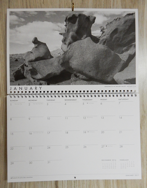
The Antarctic & Arctic Data Consortium has included two of my photos in its 2017 wall calendar (shown above and below). 7,000 calendars were printed; 3,500 were distributed at the 2016 American Geophysical Union Meeting in San Francisco. The remainder were shipped out to other organizations and collaborators.
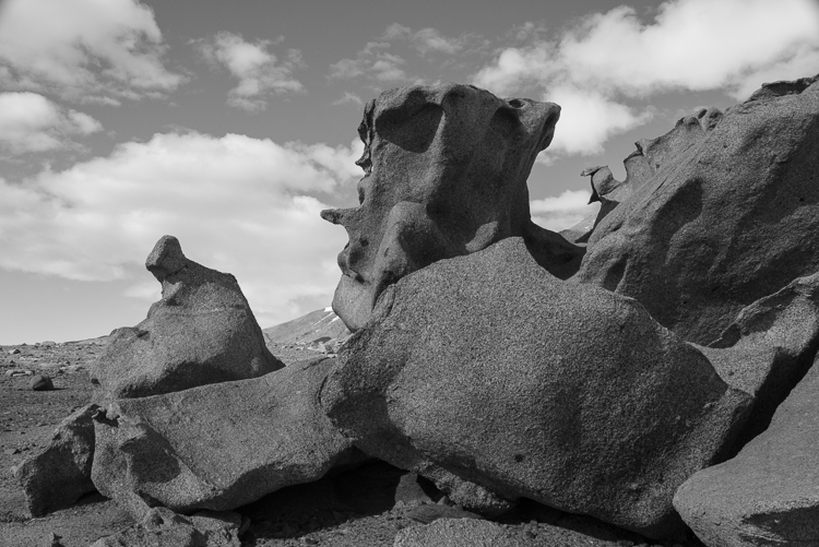
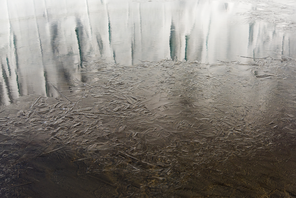
Both of the photos were taken in the McMurdo Dry Valleys when I spent a week there in December 2015. The photo above is of a ventifact field above Lake Bonney that I called the Surrealist Sculpture Garden (more about that here). The one below is a close-up of delicate ice designs that had formed over sediment atop the frozen surface of Lake Hoare (more photos here).
The surface of Lake Hoare near the field camp has an elaborate network of ablated ice structures. When the weather warms enough to melt them in December, they form intricate “drawings” in thin sheets of ice over the sediment that has blown there. This one reminded me of a skua, a gull-like bird seen along the Antarctic coast.
The a2dc (as they render their acronym) “was initiated to provide a centralized resource for scientists to submit, use, and discover polar data. The participating organizations provide the expertise and tools to support fellow polar researchers.” When I was in Antarctica, I met staff from two of the ten organizations, UNAVCO and the Polar Geospatial Center (PGC). Both organizations had offices in the Crary Science Labs at McMurdo, where their staff provided crucial mapping and geophysical data for the scientists. The PGC is based at the University of Minnesota and specializes in aerial views, assembling detailed maps from satellite photos of remote locations and have dozens of Antarctic maps online. UNAVCO works on the ground, doing GPS surveys, terrestrial laser scanning, and other kinds of measurements. An example is this two-year study which tracked the erosion of an ice cliff in the Dry Valleys and concluded that it was melting faster than anticipated due to climate change.
2017 Antarctic and Arctic Data Consortium Calendar
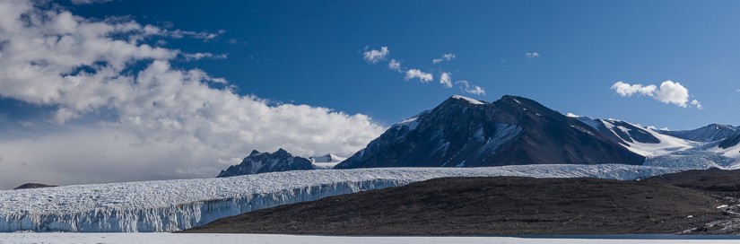
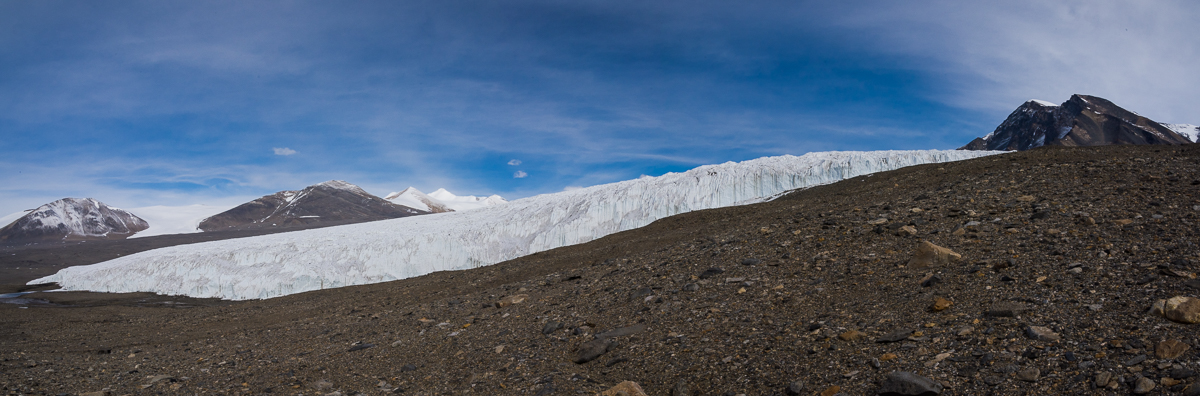
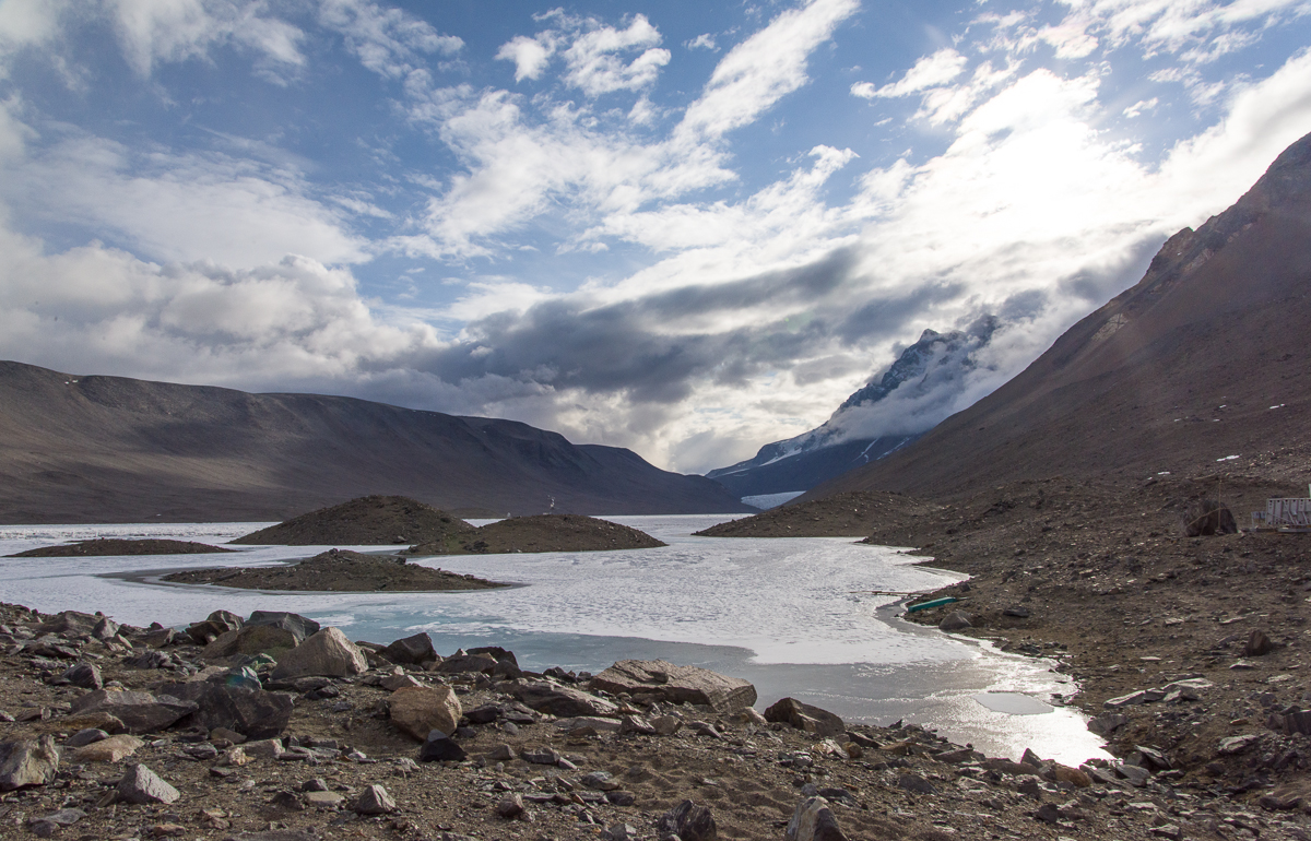
I took this photograph of the Canada Glacier from a helicopter a few days before hiking there. It gives a good overview of where we went on the hike. Lake Hoare is on the left, Lake Fryxell on the right. Halfway up the hill are the ice falls and the long tongue-like glacier that I photographed at close range in some of the pictures below.
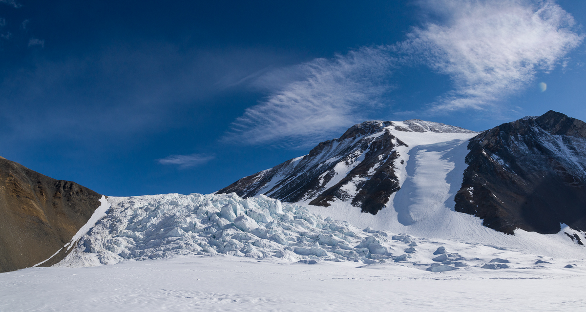
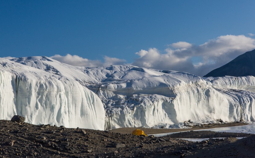
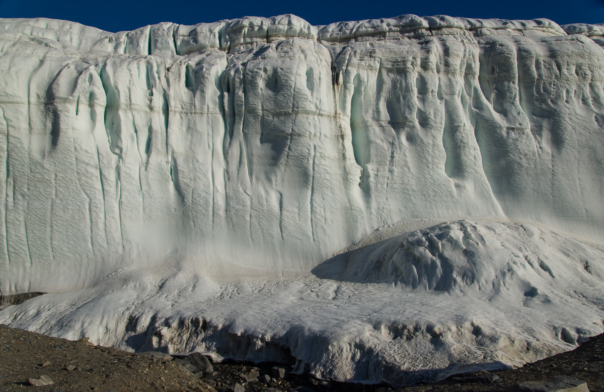
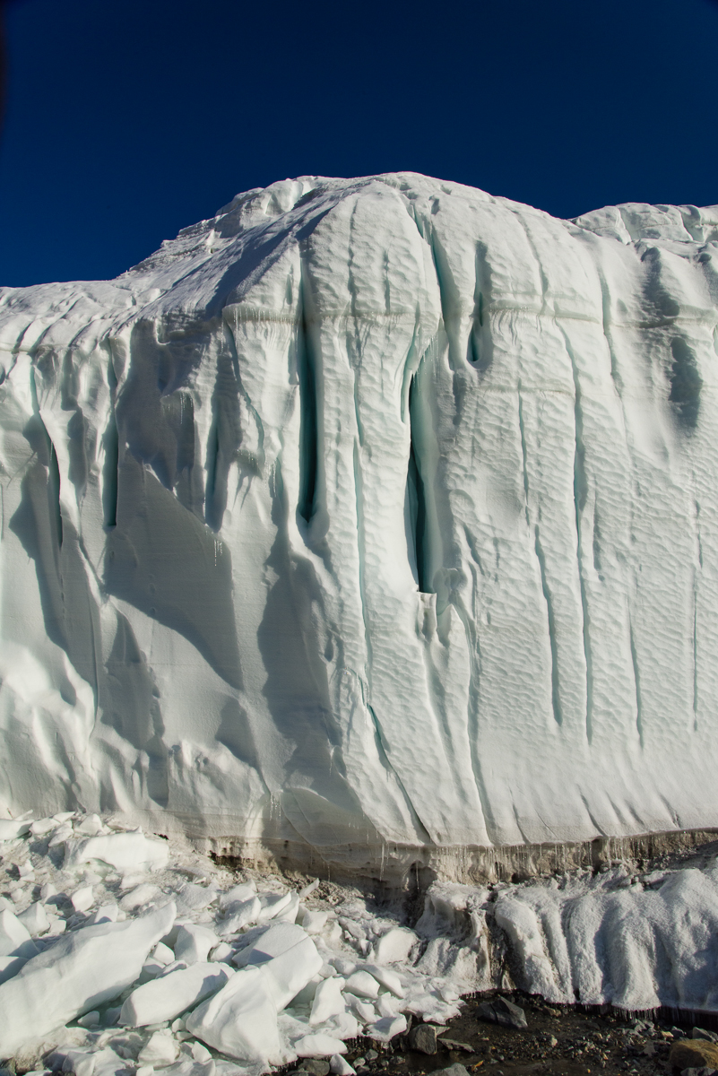
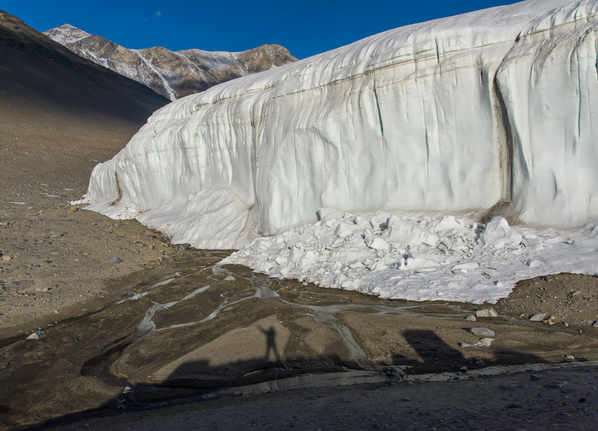
The evening of December 18th, I shook the snow off my tent from the snowstorm earlier that day and spent my first night at the Lake Hoare field camp. Though the dense fog and gray skies lingered long after the snow stopped, camp manager Rae had checked the forecast and said the skies were expected to clear overnight. Sure enough, in the morning we awoke to bright sunshine. I set out on a day hike with Renee, Rae’s assistant at Lake Hoare, to cross over the Canada Glacier and visit the eastern side, which faces Lake Fryxell. The Canada Glacier snakes down from Mt. McLennan, which is about 1,600 meters (5,250 feet) high on the north side of the Taylor Valley. The Lake Hoare camp is nestled beside the western side of the glacier, a tall wall of ice with a relatively smooth and rounded profile reminding me of an adobe house. In the course of walking over it and visiting the other side, I would see that the other side of the glacier looked very different.
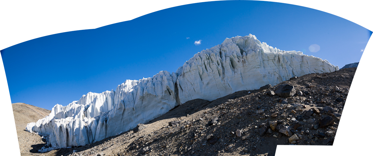
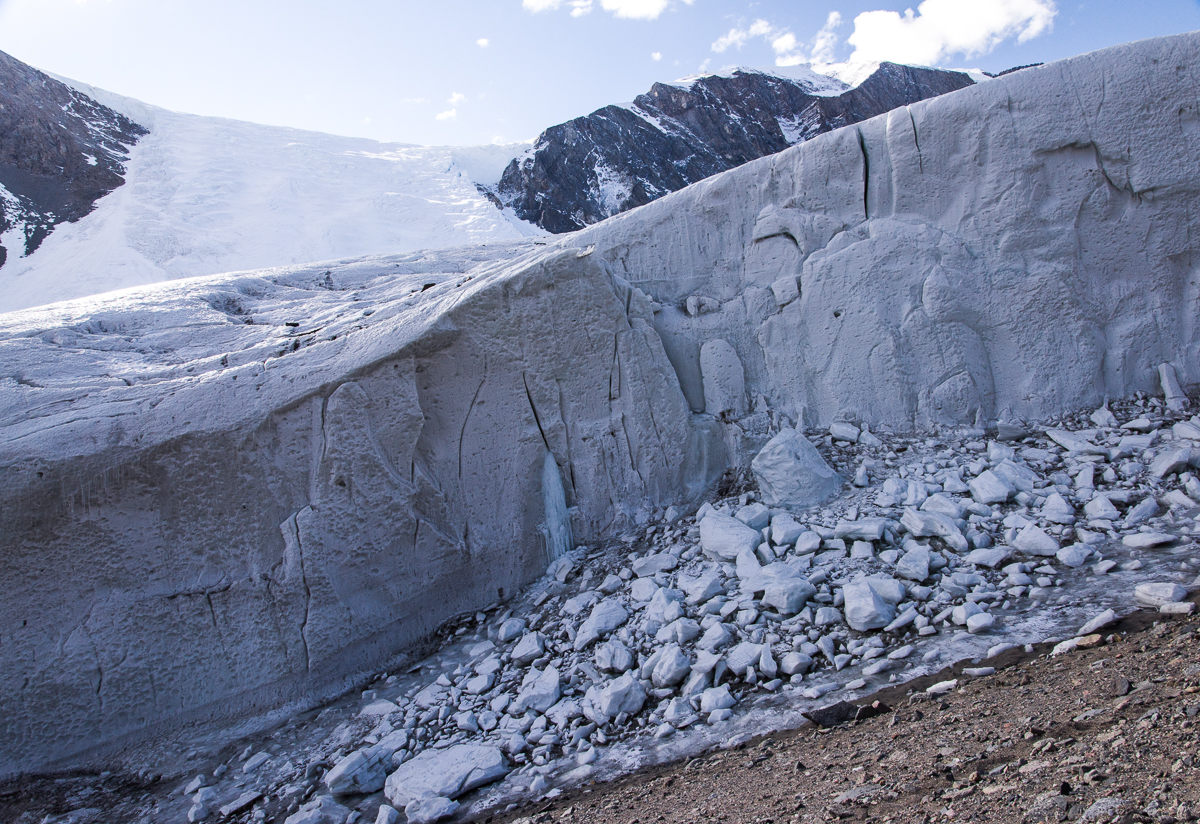
Panorama of the Lake Hoare side of the Canada Glacier beside the field camp, a smooth wall of gently rounded forms punctuated with vertical slits of deep blue ice, the very top of which is about 10 meters (32 feet) high. Beside the lake, a section of the glacier has crumbled and fallen into a pile of ice chunks. The glacier was named during Robert F. Scott’s 1910-13 expedition in honor of a Canadian who was a member of the team, Charles S. Wright.
Renee is an avid hiker who runs a backcountry lodge at Glacier National Park in Montana during the summer. Before we left, she told me, “I always hike with poles,” and offered to let me use one of hers. In all my years of hiking I had never had used walking sticks or poles; they’d struck me as just another thing to carry. But I figured this was not familiar terrain and if as strong a hiker as Renee relied on them, I’d follow her lead.
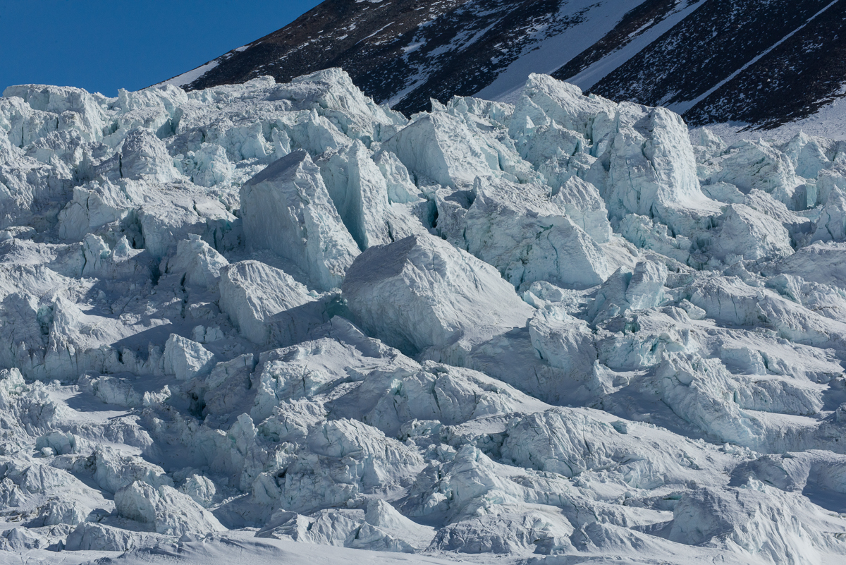
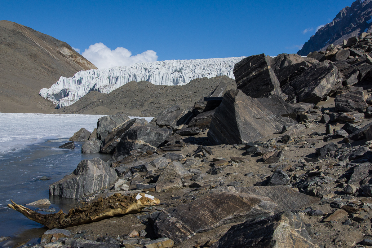
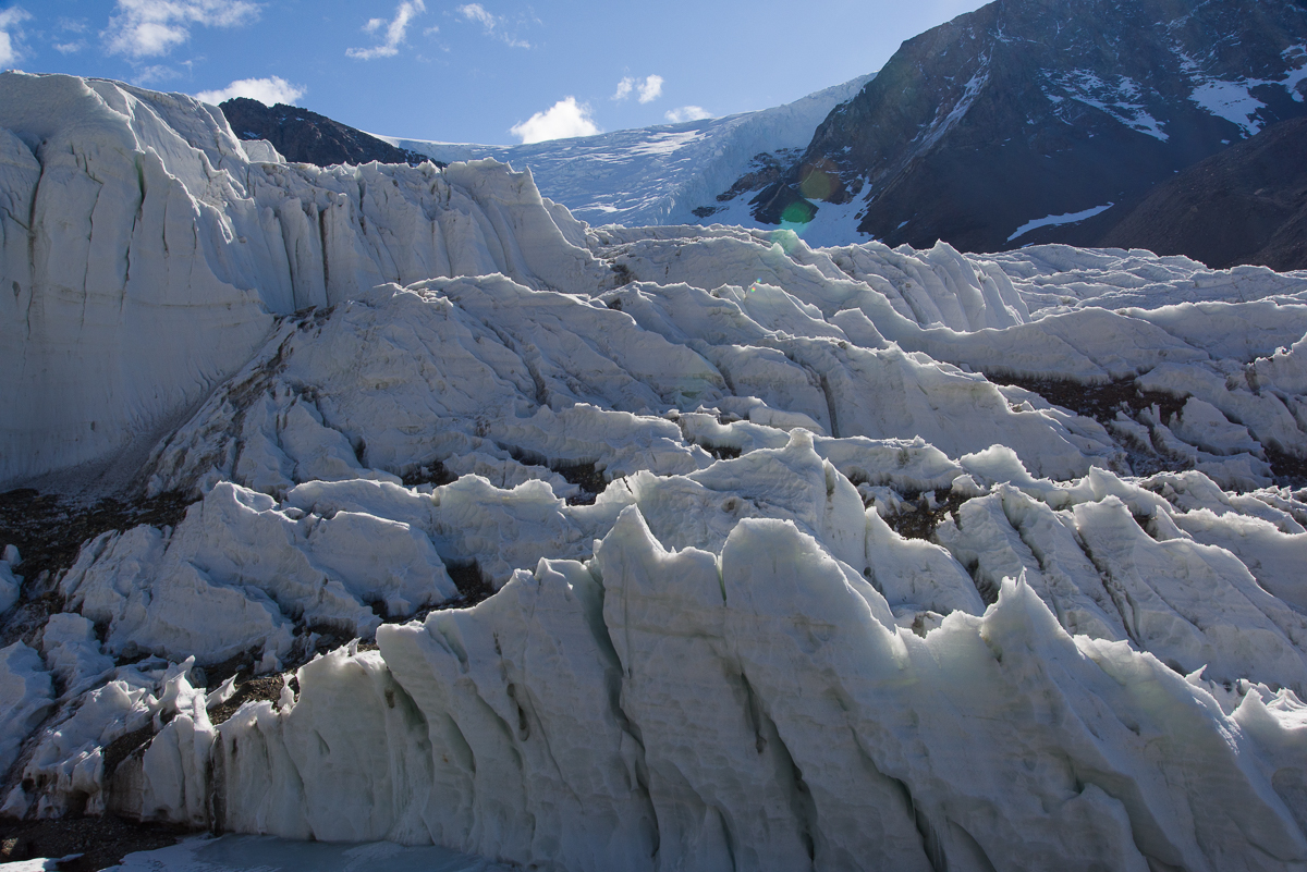
We started up the steep rocky moraine beside the Canada Glacier with the stream ecology team, who were planning to take water samples at various locations. Beside the glacier are piles of large and medium sized rocks and the Andersen Creek, fed by meltwater that comes off the glacier, but it was still so cold and shady in that area that the stream sampling team was having trouble finding thawed meltwater to collect. When we came to an area where the top of the glacier flattened out, we parted ways as they headed for another of the sampling spots. Renee and I put crampons on our boots and headed toward the ice falls, a slope where gravity had creased the glacier and separated it into rows of irregular boulder-sized chunks of blue ice. To the right of the falls, an enormous tongue-shaped section of the glacier clings to a steep face of Mt. McLennan.
When we got on top of the Canada glacier, we approached the ice falls. We got close enough for me to photograph it, but it’s not safe to walk up to the edge.To the right of the ice falls, this enormous tongue-shaped section of the glacier flows down a steep rocky slope.
Once we were on top of the glacier, I quickly discovered why climbing poles aren’t, um, pointless. The layer of about four inches of snow from the day before lay on top of the glacier, covering areas of thin ice where your foot could punch through into a hollow spot that could be anywhere from a few inches to a couple of feet deep. Underneath could be rocks or small melt pools. This made traversing the area more challenging than usual, when the hazards are more visible. As she walked, Renee rapidly jabbed at the ice ahead with her pole. If the pole punched a hole in the ice, then she’d pause and continue probing until she found a solid spot before taking the next step. I followed suit. Here is a detail of the ice falls, taken with the assistance of a telephoto lens:
Ice sculpture: enormous chunks of blue ice form creases, ridges and terraces on the hillside.
After photographing the falls, we continued over the top of the glacier, carefully poking the surface with our poles to avoid the gaps until we stepped off the glacier onto the rocks and gravel on the other side. We looked for tracks where the stream ecology researchers had walked before, but couldn’t always find them, so we had to pick our way carefully, especially when we got close to the edge where the glacier tapered off onto the gravel-covered hill. To the south, there were thin clouds in the sky and the previous day’s snowfall gave the opposite hillside the texture of a tapestry:
On the south side of the valley across from the Canada Glacier, the Kukri Hills were dusted with the previous day’s snow. Before that, they were mostly bare and brown.
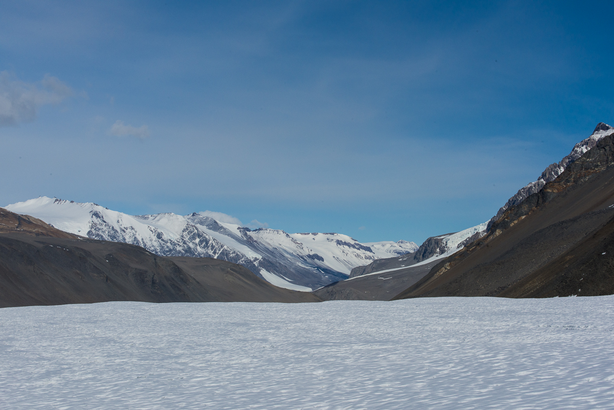
Looking toward Lake Hoare while standing on top of the glacier you can take in its scale. We had walked up from the right:
View of Taylor Valley from on top of the Canada Glacier.
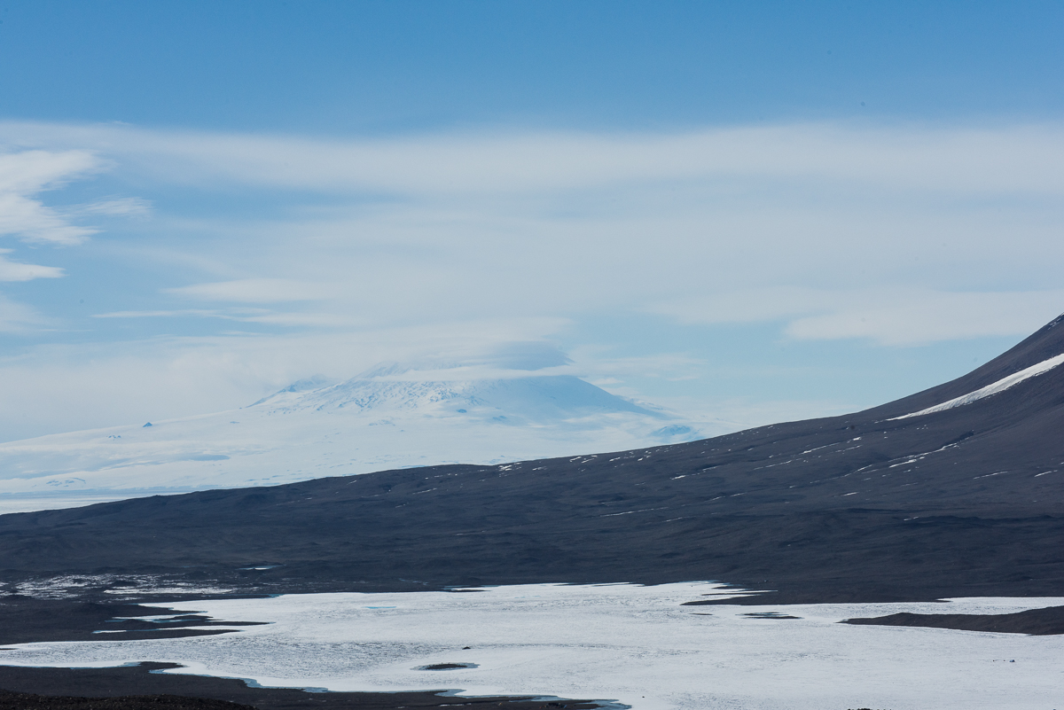
Our next destination, Lake Fryxell, lay ahead to the east. We were up high enough to see the ice-covered summit of the Mt. Erebus volcano in the haze across McMurdo Sound about 13 miles away. After crossing the glacier to the gravel hill on the other side, we ate lunch in a sheltered spot, then headed downhill towards the Lake Fryxell field camp. Our plan was to get in the ATV that stays on the sea ice during the research season and double back across the lake ice to have a closer look at the Fryxell side of the Canada Glacier.
Lake Fryxell from the Canada Glacier. The 12,448-ft. summit of Mt. Erebus, about 13 miles away, can be glimpsed through the haze.
In order to protect the ecology of the streams which run off the Canada Glacier into Lake Fryxell, approximately one square kilometer of the hillside adjoining the glacier and the lake shore has been designated an Antarctic Specially Protected Area (ASPA). Although it looks like just more of the same rocks and gravel you can see for miles in every direction, its relatively sheltered location and the meltwater coming off the glacier makes this tract one of the best places to find life in the polar desert, especially bryophytes (e.g. mosses) and algae. The tiny plants are freeze-dried most of the year, but come briefly to life during the austral summer. To enter one of five ASPAs in the McMurdo Dry Valleys, you must be issued a permit by a national authority, which for the U.S. is the National Science Foundation. I obtained a permit to enter the Blood Falls ASPA but not the Canada Glacier one. The NSF staffer who issues the permits assured me I would be able to get close enough to the glacier from the lake to photograph it and that there was no reason for me to enter the protected site. When I got there, I could see her reasoning. That portion of the glacier isn’t even particularly interesting from a visual standpoint:
One square kilometer adjoining the Lake Fryxwell side of the Canada Glacier on the lower part of the hillside (to the left in the above photo) is off limits to all except scientists with government-issued permits.
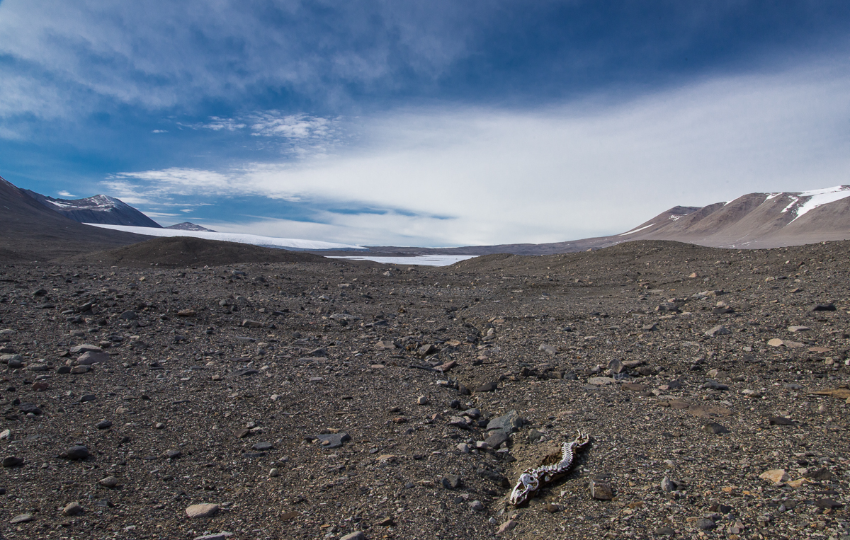
Hiking across the gravel to Lake Fryxell we encountered the first of two mummified seals. I made a tentative ID of the one below as a crabeater seal, based on its teeth. The three types of seals found in this part of Antarctica — leopard seals, Weddell seals and crabeaters — all have different shaped teeth.
On the way from the Canada Glacier to the Lake Fryxwell camp we encountered a mummified seal that was mostly reduced to a skeleton. The animal must have been very disoriented as it laboriously crawled over the land, because it died headed in the opposite direction from the sound after traveling several miles. In the distance the small white wedge in the center is Lake Fryxell. Beyond that on the left, is the Commonwealth Glacier.
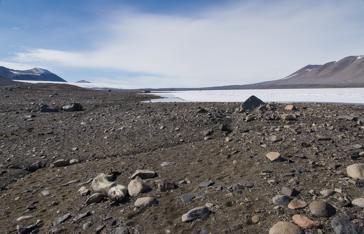
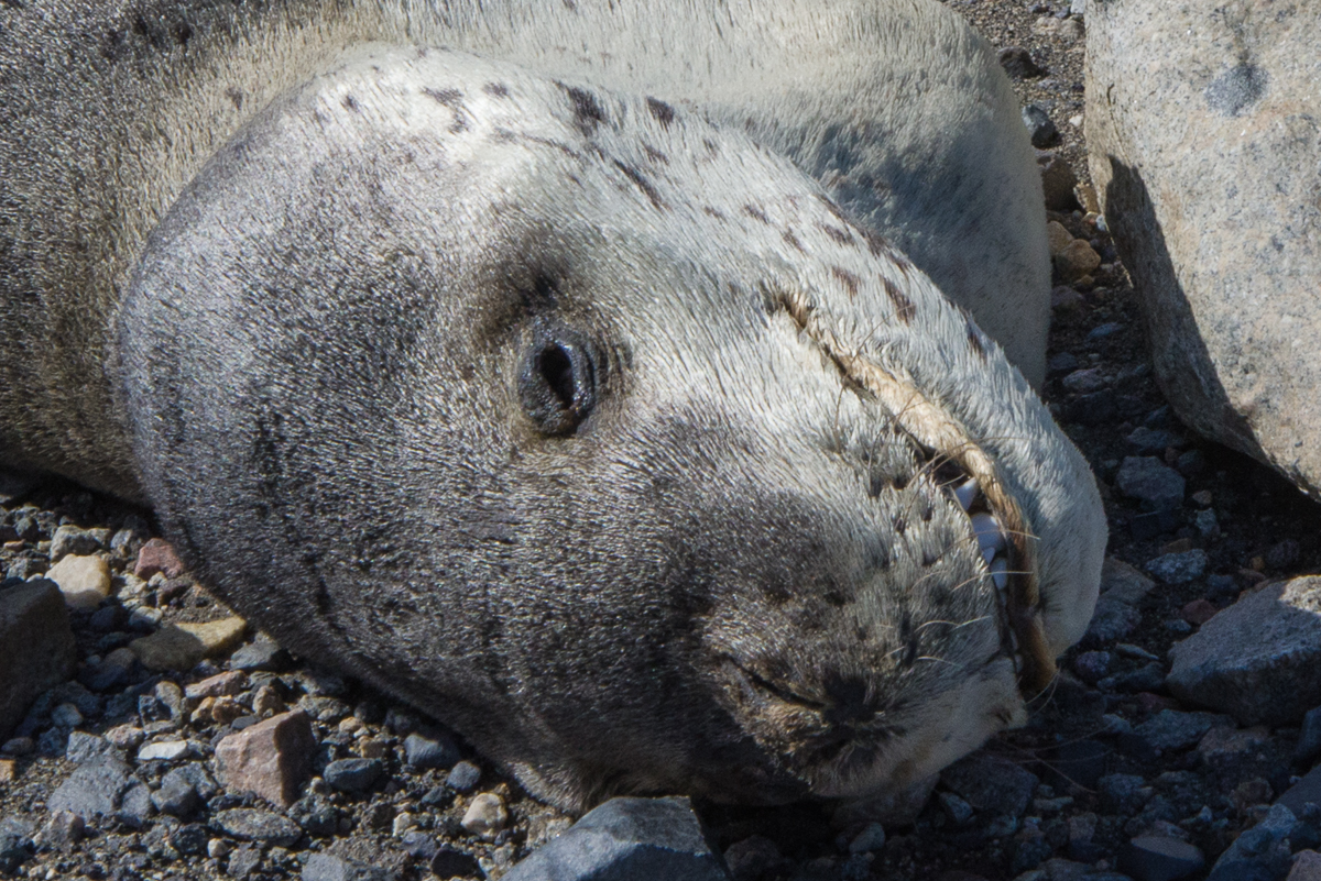
The next seal we encountered was easily identified as a leopard seal, because due to the freezing temperatures and the lack of organisms such as bacteria and insects, it still had its fur, even though, according to the people at Lake Hoare, it had died there about three years ago. Leopard seals are ferocious predators — when I asked Sam Bowser if his dive team ever saw them at New Harbor, he responded, “No! And I wouldn’t want to.” Leopard seals could attack the divers. Weddell seals, which the divers often do see, are essentially harmless and non-intimidating, even though they weigh over 1,000 lbs. But even a young leopard seal that had drawn its last breath a few years ago looked somewhat sinister with it’s long powerful jaw.
Between the Canada Glacier and Lake Fryxell we approached a more recently deceased seal. It’s difficult to determine how long most of the mummified seals of the Dry Valleys have been there, but because this area is frequently traversed by scientists during the research season, they know it showed up around three years ago.Close-up of the seal shown in the previous photo. After three years, it has hardly decomposed and still has its fur. Leopard seals are fierce predators and you would not want to get this close to a live one.
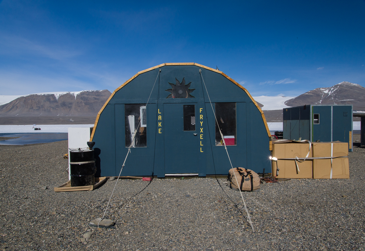
Eventually, we reached the Lake Fryxell Jamesway hut. Nobody was staying at the field camp, though a team of carpenters were expected to return shortly to resume work building a new hut on the site, of the same design as the one at Lake Hoare. When they’re done, the Jamesway will be dismantled, and these photos will be documents of a vanished era. The Lake Bonney Jamesway will be replaced next. There’s something cool and retro about the Jamesways, especially the quirky improvisations and embellishments added over the years as teams of researchers have come and gone, but whatever the boxy Lake Hoare hut lacks in character it is way more functional and comfortable.
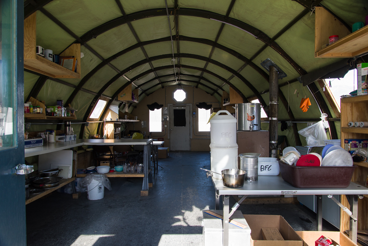
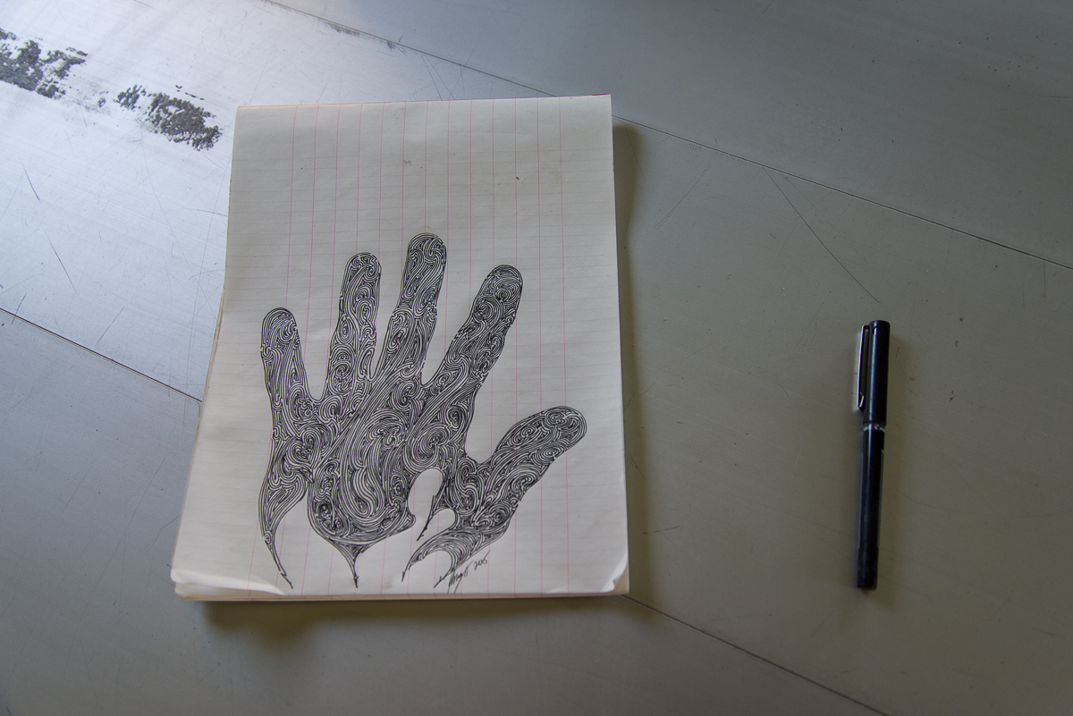
Take a good look at the Lake Fryxell hut, because it won’t be around much longer.Inside the Lake Fryxell Jamesway, with the kitchen area in the foreground.Renee and I stopped inside the hut for a snack. Someone had passed their down time making an intricate drawing on graph paper, signed, dated and left behind on the kitchen table.The newer huts will look like the one at Lake Hoare.
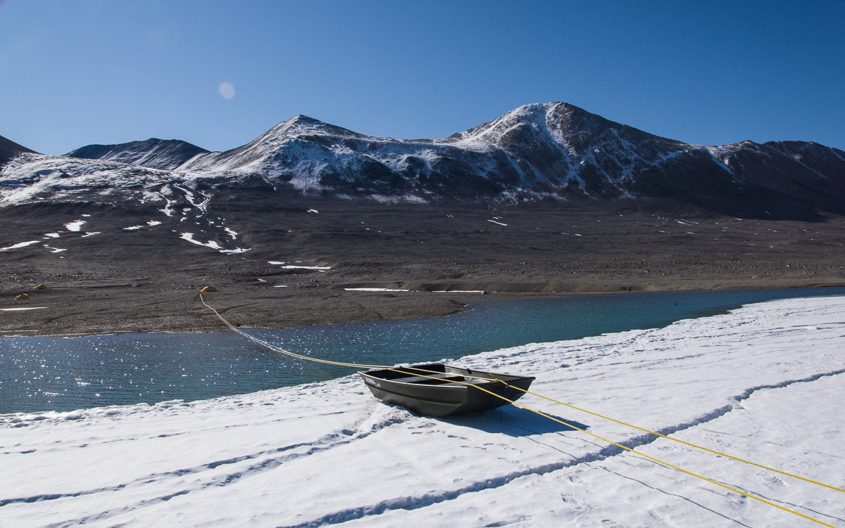
After eating a snack in the hut, we headed for the ATV, which was parked on the thick, permanently frozen layer of ice that covers Lake Fryxell. This time of year, the margin of the lake melts, and is a few feet deep. So how do the limnologists (lake scientists) get onto the ice? The ingenious solution, arrived at with Rae’s input, was to have an aluminum rowboat rigged up so that at either end a loop of rope was attached to the boat. Through those loops runs a very long loop of yellow rope, which is threaded through two pulleys, one set up on shore and one on the ice. Get in the boat, pull the yellow rope hand over hand and the boat travels across the water and glides up onto the ice. It kind of reminded me of the old rope tows at ski areas in the 1960s and ’70s.
Once on the lake ice, we walked to the ATV, pulled out the pan underneath it protecting the ice in case oil dripped from the engine (every effort is made to not have any alien materials enter the environment), and made sure the tires weren’t frozen to the ice. Renee got it started, I straddled the back part of the seat behind her, and off we went.
Pull, pull, pull your boat, gently ‘cross the stream.
Renee drove cautiously, taking care to not drive too close to cracks around the periphery that might indicate unstable ice, and slowing down when crossing rough areas, which we encountered increasingly as we approached the glacier. I was grateful that she took her time and I wasn’t being bounced around on the narrow back part of the seat. Later on, when we were back at the hut, I told her that I’d appreciated her restraint. She burst out laughing and said, “Oh good! I was thinking, ‘She must think I’m such a wimp!'”
In the distance, Renee waits at the ATV for me to finish photographing the glacier. There were some raised areas of ice at that end, left behind when the rest of the lake ice surface ablated (vaporized). There is nothing as irregular as the ice structures on Lake Hoare, but driving over and around them made for a bumpy ride in places.
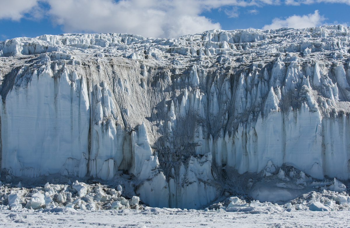
The Lake Fryxell face of the Canada Glacier looks completely different than the Lake Hoare side. For one thing, at its tallest, it’s about twice as high — around 20 meters. That’s because the land slopes beneath it and the surface of Lake Fryxell is actually about 55 meters lower in elevation than that of Lake Hoare. If you look at the second photo from the top of this post, taken from a helicopter, you can see the slope. I am guessing that it’s this downhill gravitational pull as well as the directions of prevailing winds and sunlight that make it look so different — spiky and Gothic with narrow pointy-topped spires, as opposed to the rounded contours on the west-facing side, which get the warmer afternoon and evening sun.
The Canada Glacier as seen from the far west side of Lake Fryxell looks like a packed metropolis of ice steeples.
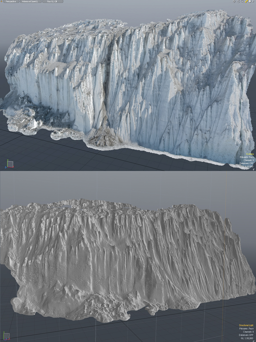
Renee waited patiently while I shot some 300 photos of the glacier side. That’s way more photos than I usually took at a site, because I wanted to see if I could produce a 3D capture (i.e. scan) of the complex surface, and since I hadn’t had much experience tackling something that is both that immense and that detailed, I wasn’t sure how many different angles I would need. So I decided to err on the side of “more than enough.” Eventually some of these 3D captures will be produced as sculpture. (Read more about the process.) Recently I processed one section that I shot that day. It took the software about 18 hours to calculate the relative distances between points to produce a model of the section below, and another few hours for it to generate a polygon mesh, but I’m really pleased — and relieved — with the results. Below is one of the source photos, followed by screenshots of the model.
Source photo of a section of the Canada Glacier from Lake Fryxell.Two screenshots of the model produced by uploading 28 still photos to photogrammetry software. The software also captures the surface color from the photographs. The top view shows the model with that color, the bottom shows the mesh without the color. As you can see, the software was able to figure out the locations of points in space so that you can look at the model from elevated vantage points I did not have, which is pretty remarkable when you think about it. All my shots were taken looking up at it from the lake. I photographed a much longer extent of the glacier so if the software can handle it, I might be able to get and even longer model of that side. I also have photos of a long section of the opposite side yet to process.
After returning the ATV to its parking place, the hike back to Lake Hoare was more challenging than the hike out had been, due to gusty winds that had kicked up. The rowboat tilted to one side while Renee was pulling it to shore and I immediately shifted my weight onto the gunwale to stabilize it, to her great relief (amazing how those instincts kicked in from the long ago days of taking out sailboats at Camp Whippoorwill, when I was 13 ). The sky started to cloud, and on the top of the glacier, the previous day’s snowfall was swirling around, making me even happier to have a pole in my hand to prod the ice in front of me, and also glad that I’d stopped to photograph the ice falls in the morning. Then we walked down the moraine to camp.
All told we’d been out for about eight hours. Photographing — or for that matter doing scientific research — in the Dry Valleys is often very physical, and involves a lot of walking up and down hills while carrying a pack. And I still had a lingering cold the entire time, but was damned if that was going to stop me. Last week a woman who writes a travel blog called me up to interview me about the Antarctica trip. She asked about my formative travel experiences. This got me thinking about the aforementioned Camp Whippoorwill, where I was introduced to hiking and camping in the Adirondacks, and Crossroads America, a cross-country teen tour I took the summer I turned 16. I spent those nine weeks riding around the U.S. in a Ford Econoline van with nine boys and girls and two adult leaders whom I’d never met before the day we started out. All my belongings were in a duffel bag, we camped outdoors almost every night, and we all had to get along with kids at close quarters whom we might not otherwise have chosen as friends.
I’m grateful and maybe a little surprised to arrive at this age with the energy, physical conditioning, and the ability to tolerate a lack of creature comforts and to roll with the inevitable glitches that arise, but I think it goes back to those formative experiences: reaching the summit of an Adirondack peak on a day where you could see for miles, singing to keep our spirits up while we walked in plastic ponchos getting drenched with rain, campfire meals of tuna-rice-a-pea (open cans of tuna, rice, peas and cream of mushroom soup, and stir), picking up my ground cloth after sleeping in the open at the bottom of the Grand Canyon to find a little white scorpion had also spent the night there. Somewhere were planted the seeds of confidence, resilience and determination to push onward until you reach your destination that have never left me. I think my teenage self would have been happy to know that.
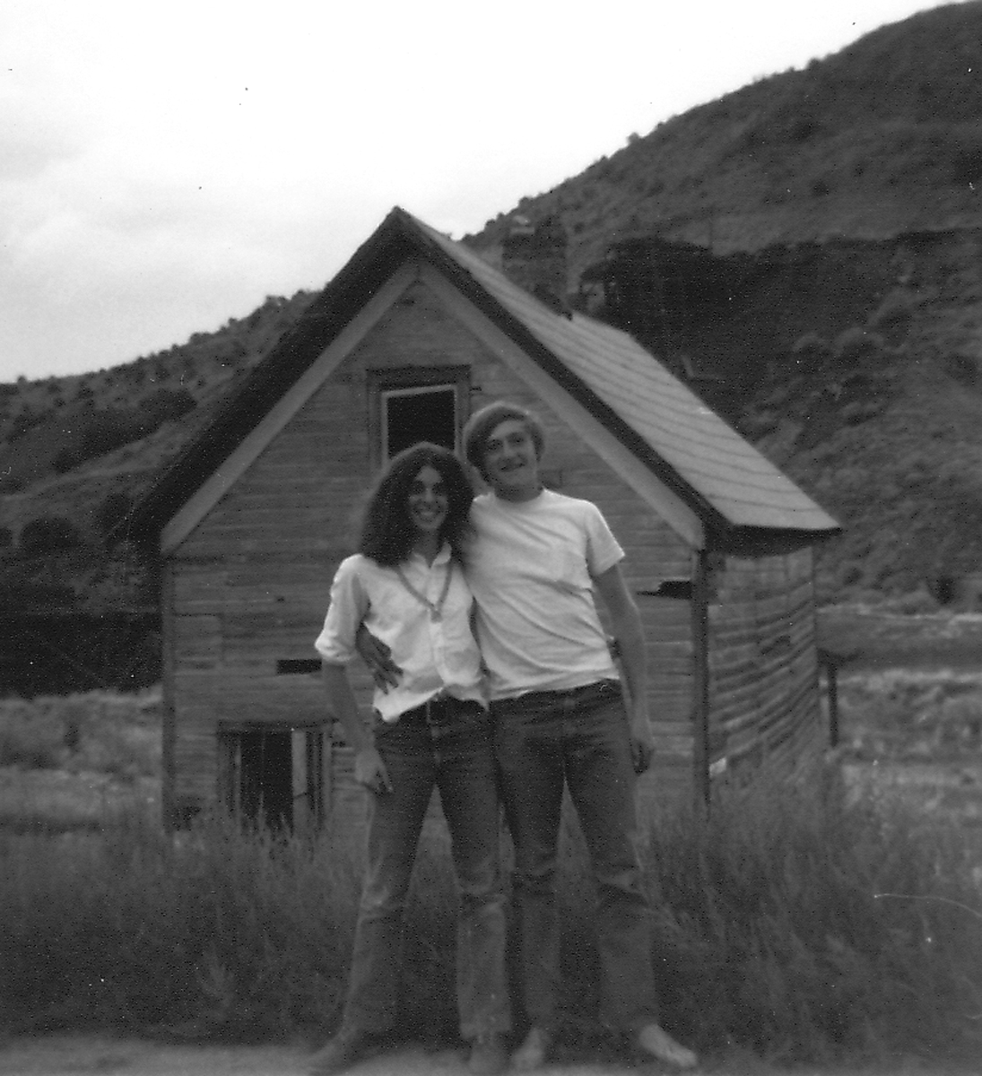
With one of my fellow travelers in a New Mexico ghost town on the Crossroads America trip, 1971.
The Lake Hoare field camp in the McMurdo Dry Valleys, where I spent five days, sits at the east end of the lake right next to the immense Canada Glacier. At the opposite end of the lake is the smaller Suess Glacier. When I first heard the name, it would not have surprised me if a glacier in Antarctica had been named for the children’s book author Dr. Seuss, given the odd landscape features that resemble some of his fanciful illustrations. But no, the 1910-13 British Antarctic expedition led by Robert F. Scott named it for Professor Eduard Suess (1831-1914), a prominent Austrian geologist and paleontologist who helped lay the basis for paleogeography and tectonics.
View up Lake Hoare from the field camp. The tiny inverted white triangle at the end is the Suess Glacier.
One day I hiked there accompanied by Mari, a young woman who normally worked at McMurdo in the field camp supply center, but was spending a couple of weeks at the Lake Hoare camp assisting camp manager Rae during a particularly busy period of the research season. There are many people in their twenties who work 10-hour shifts, six days a week at McMurdo during the austral summer as dining hall workers, supply staff, janitors, cargo loaders, etc., but their opportunities to travel beyond the base are limited. So Mari was thrilled to be in the Dry Valleys and enthusiastic about hiking to the Suess. We followed a path of sorts that had evolved from the walks of other researchers, which wound around the perimeter of the rocky north shore of the lake (on the right in the photo above).
As we approached the Suess Glacier, we came upon a mummified seal.
After about an hour, we came across a mummified seal. Positioned on its belly rather than laying on its side made it look curiously animated, as if it was in the process of clambering out of the water. The mummified seals strewn throughout the Dry Valleys are an enduring mystery, and one I plan to write more about in a future blog post. Suffice to say, the icy climate and lack of organisms to break down dead animals keeps them in a state of preservation such that it’s difficult to know if that seal has been there a few years or a few hundred.
Mari scouts the best path around a large hill of gravel.
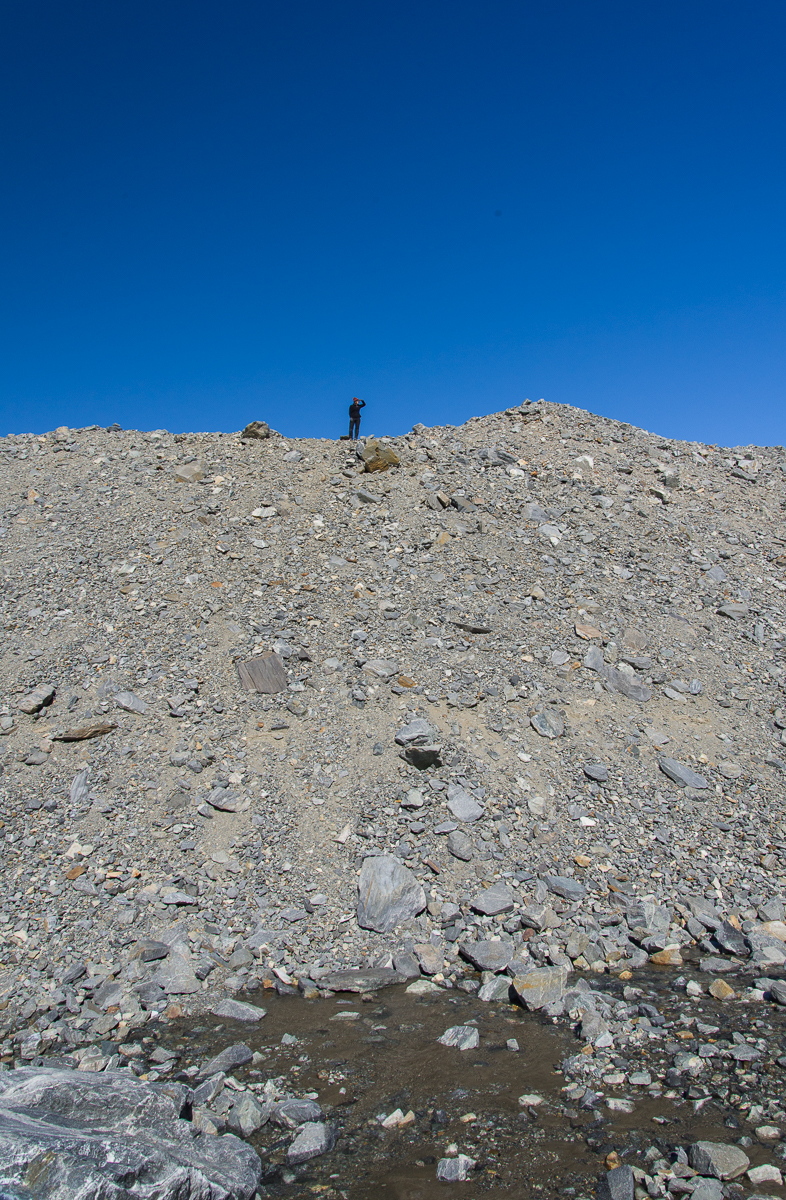
As we continued following the lake’s shoreline, we soon reached a very tall gravel hill that blocked our view of the glacier. Mari climbed to the top to scout the best route around it (remarkably quickly, too — it’s hard to get a footing on steep, loose gravel). As you can see in the photo at left, a stream of water was running downhill off the glacier into the lake. Mari had determined there was no shortcut to the glacier from where we were so we continued around the lake side of the hill.
From the Lake Hoare side, the Suess glacier is not nearly as impressive as the Canada Glacier in size or height. This panorama made from three negatives is pretty much what you see as you approach from the lake:
Panorama of the Suess Glacier from the end of Lake Hoare. The glacier flows downhill from the right and comes to rest against the steep gravel hill on the left.
Walk around to the left of it and you can look uphill to see it flowing from the crest of the hill on the right:
The Suess Glacier, looking uphill to where it begins.
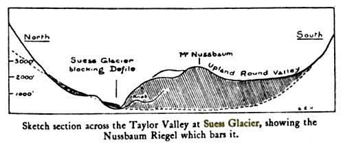
But the really good stuff was just around the corner. The Suess flows down one steep hill and comes to rest where another steep hill meets it, forming a narrow passage called a defile. Once you enter the defile, you encounter another side of the Suess, a towering wall of glistening scalloped ice. It glowed with a peachy color reflected off the gravel hill:
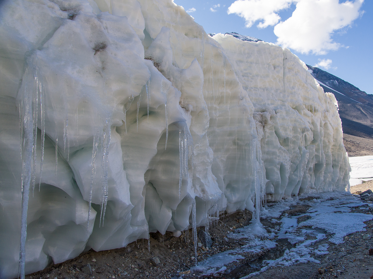
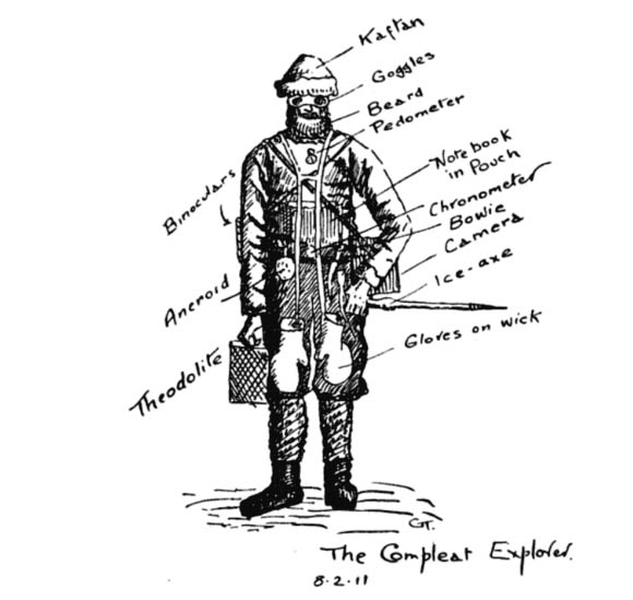
At the beginning of the defile, looking back toward Lake Hoare, the Suess turns into a wall of wind-scalloped ice and icicles.Griffith Taylor’s sketch of “The Compleat Explorer” was made on February 8, 1911, in the midst of exploring the valley that came to be named after him.
One of Scott’s party in the 1910-13 expedition, the geologist Griffith Taylor, described the discovery of the Suess in his 1916 book With Scott: The Silver Lining (you can find the section referred to here on Google Books). The title implies a motivation to spotlight the expedition’s accomplishments and successes, which had been to some degree overshadowed by its sad ending, when Scott and four of his men died on their way back from the South Pole. The following year, World War I broke out and was still raging when the book was published. As the book’s editor, Leonard Huxley, put it in the Introduction, “It is for Mr. Griffith Taylor to tell of the daily life of that company from within, to tell in careless detail its lighthearted cheerfulness lining solid effort, which the cloud of English earnestness so constantly turns out upon the night.” The section on the journey through what is now known as the Taylor Valley exudes the joy of discovery and is illustrated with Taylor’s charming drawings, including a humorous depiction of “The Compleat Explorer” wearing the state-of-the-art cold weather gear for 1911. (This includes “Beard,” which continues to be a popular male accessory in Antarctica. Once somebody said, “You know who I mean? The tall guy with the beard,” and the rest of us started laughing since that did not narrow it down at all.) At any rate, I’m guessing the Dry Valleys were associated with particularly fond memories for Taylor, because along the way Scott informed him he was naming the magnificent Taylor Glacier after him! Taylor’s book also includes his sketch of the Suess:
Sketch of the Suess Glacier by Griffith Taylor, made in 1911 when he explored the area with Robert F. Scott.
Taylor and company approached the Suess from the west, i.e. the opposite direction we took. His description remains apt today: “a face of ice forty feet high; but just where it butted into the steep south slope of the defile, there was a narrow gap where thaw-ice had filled in the interspaces between the cliff debris.” Mari and I put on crampons (velcro sandals with spikes on the soles) over our boots to walk on the icy passage where it narrowed to the width of a typical sidewalk.
We walked alongside a wall of ice with such hard, polished surfaces that it looked like it had been cast from a mold:
The side of the Suess Glacier bordering the defile is very different in appearance from any other glacier I saw: an icy, dimpled wall. Maybe it has to do with facing the defile, where it gets little sun and the wind is funneled through the narrow gap.
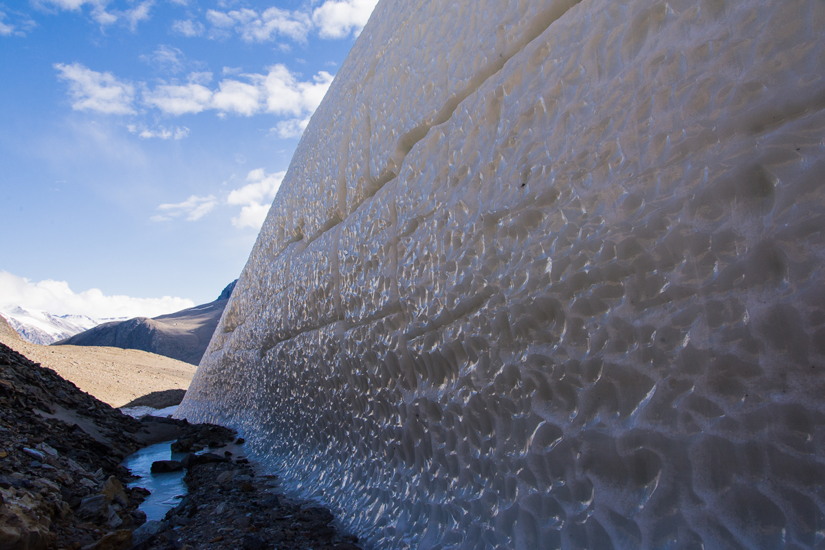
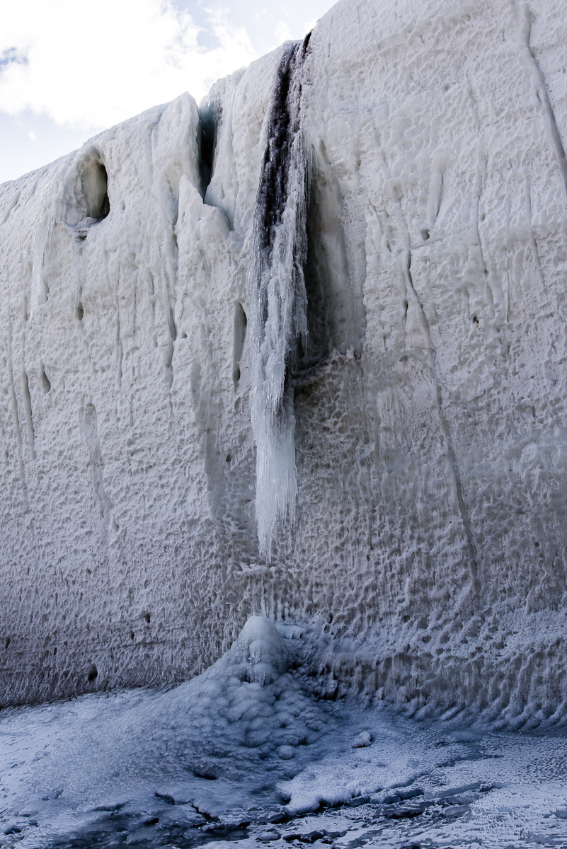
We also encountered the most impressive frozen waterfall I saw anywhere in Antarctica:
Freezing the action: a frozen waterfall of ice and sediment was an impressive sight.The other side of the frozen waterfall along the defile.
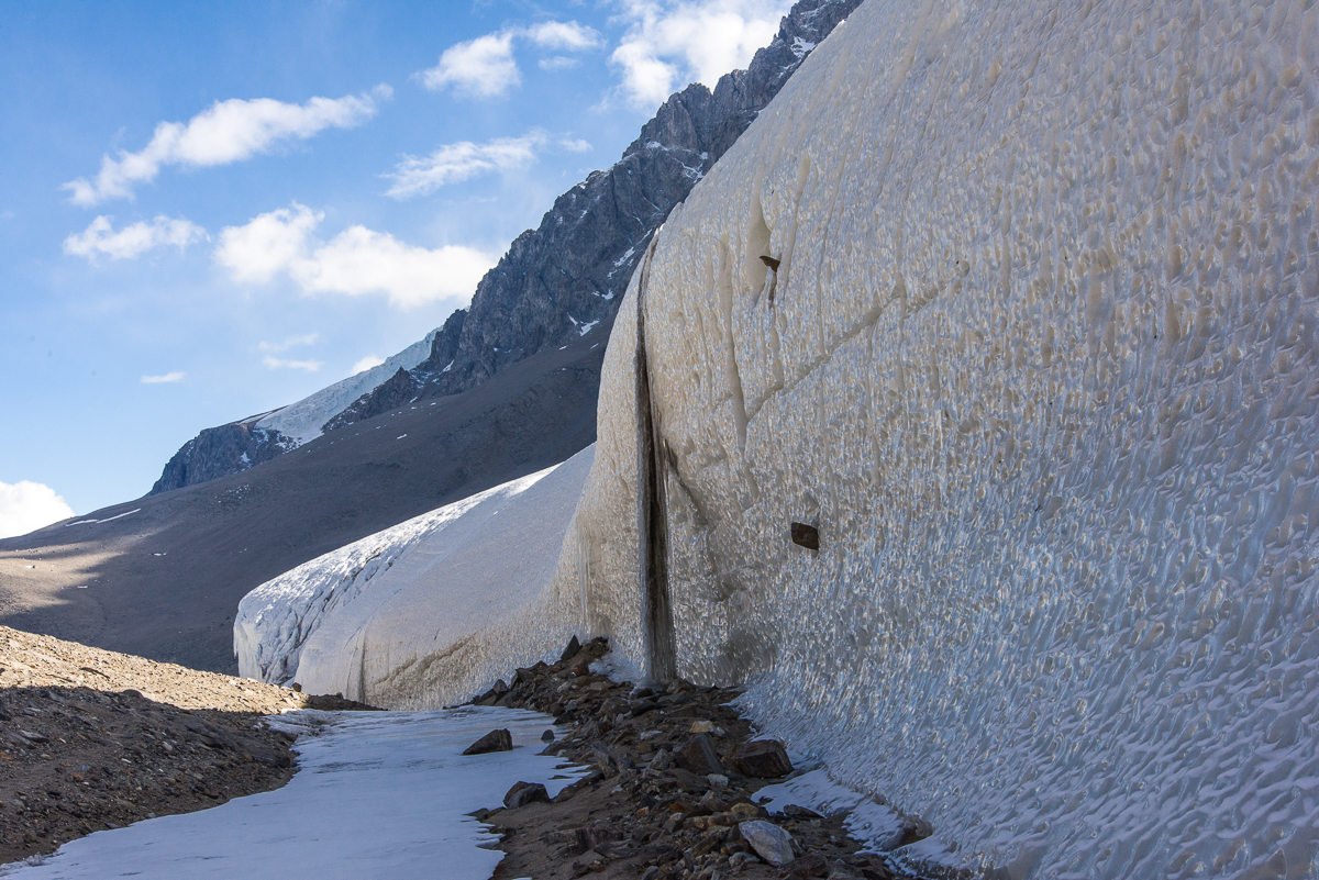
I was fascinated by the large rocks protruding from the icy wall that had apparently been swept up by the slow-moving glacier long ago. You see a couple of them in the photos of the waterfall above. The one below had to weigh several hundred pounds, and yet was somehow securely frozen in place in its icy niche:
That’s a big rock! And it looks like it’s not going anywhere anytime soon.
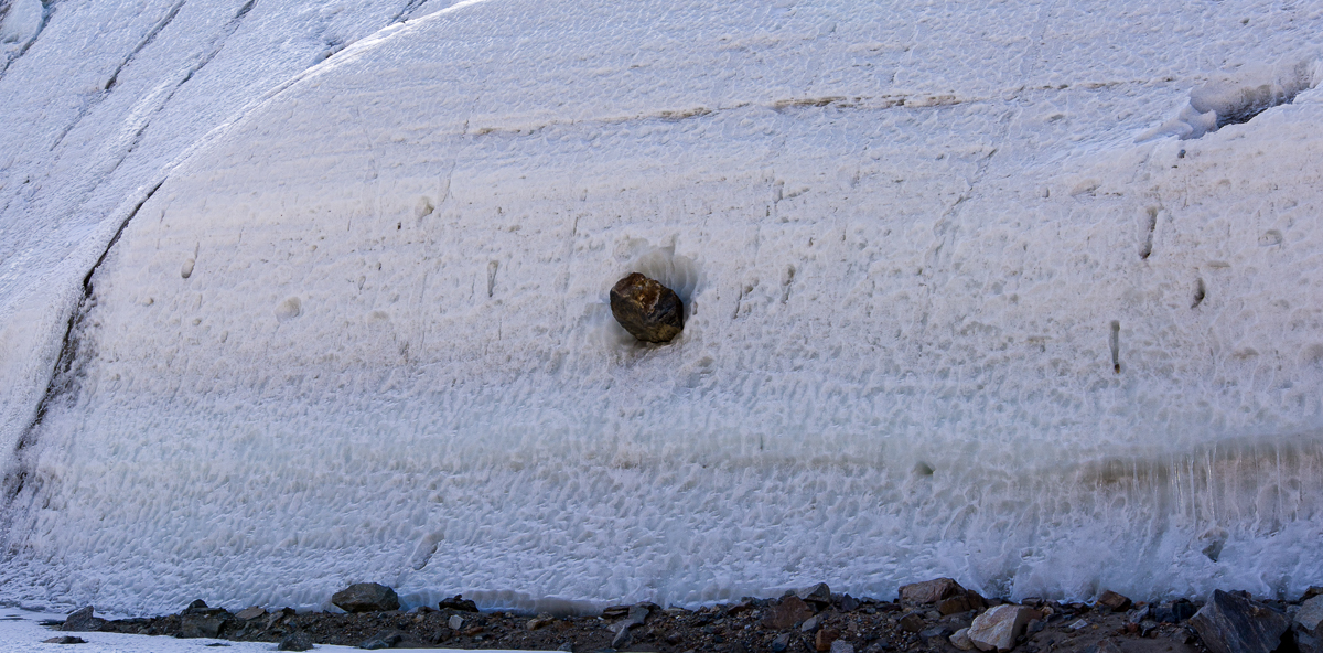
Toward the end of the defile, where the narrow space opened up and the glacier height tapered off, another frozen waterfall had formed an ice stalactite and stalagmite:
A smaller frozen waterfall gives an idea how the larger one probably looked before it connected into a column.
Once out of the defile, the Suess presents yet another aspect, a frieze of rounded shapes:
The icy dimpled surface gives way to a frieze of smoother, rounded shapes.
We reached the end of the defile, and looked down at the small blue lake on the other side (below). It was 5 p.m., we’d been out for four hours and decided to go back to the camp, figuring we’d be there in 90 minutes, just time for dinner. That was the time we decided to take a direct route back across the lake ice which turned out to be, ah, no shortcut at all for us lake ice rookies. If you haven’t read that story, you can find it here. Long story short, we made it back, albeit almost three hours later with wet socks. It was unnerving while we were in the middle of it, but funny once it was over: silver lining!
The west side of the Suess Glacier faces a small lake.
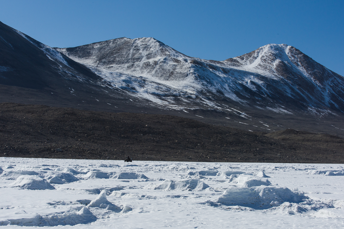
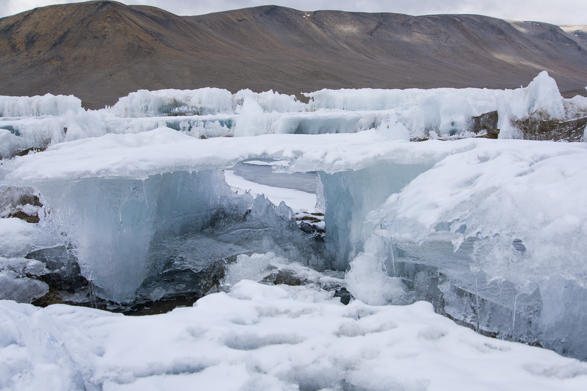
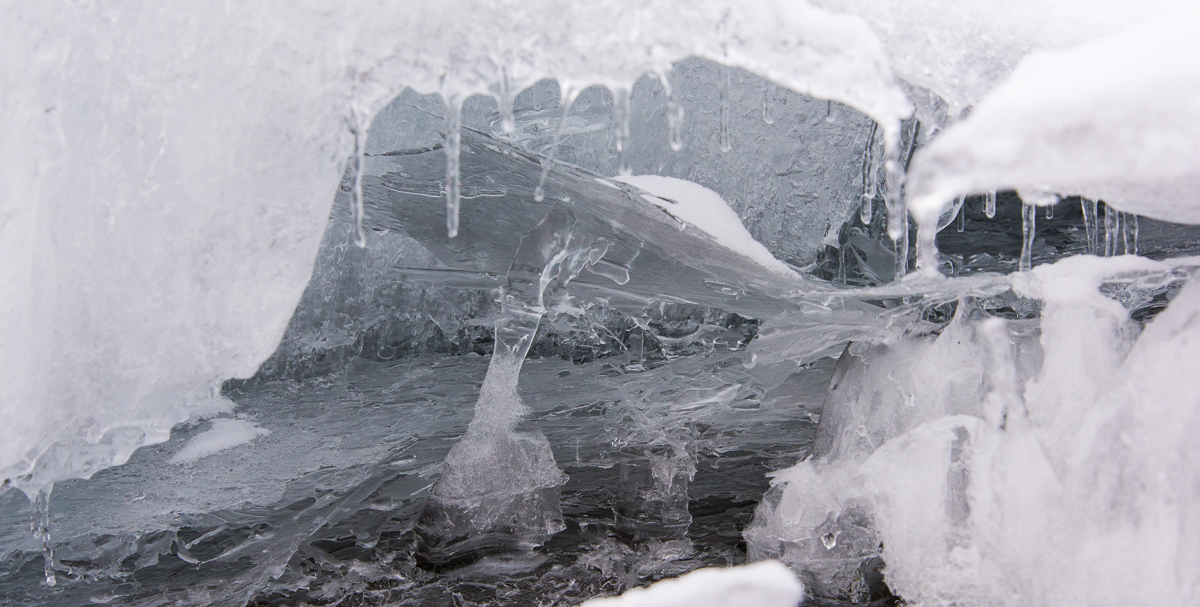
This isn’t the shore of Lake Hoare, this is what large sections of the lake surface looks like when you walk onto it, especially at the end closest to the Canada Glacier. You wander between flat-topped structures two to three feet high, the tops having formerly been the surface of the lake. The rest of the lake has ablated (vaporized into the air) leaving this peculiar world of glass-like ice architecture and thin, delicately etched pieces on the sediment around them.
As I mentioned in a previous post, the lakes in the Dry Valleys have a permanent crust of ice that’s on average four meters thick, a thickness that stays constant from year to year. The lakes themselves can be as much as 30 to 112 feet deep. The thick ice layer is added to by water freezing from the bottom, while the top is lost to ablation — that is, it goes from solid to gas. Scientists who studied the lakes used to think that 30 cm was added to the bottom and 30 cm was lost from the top each year, but recent research suggests that the average rate is more like 75 cm.
Some of the tops cantilever out so far without much support you wonder how they haven’t collapsed yet.Lake Fryxell has some flat-topped ice structures at the end near the Canada Glacier, but they aren’t as extensive or complex as the Lake Hoare ones, and are spaced farther apart. Most of Fryxell looks like this. Researchers routinely drive an ATV across it with ease.
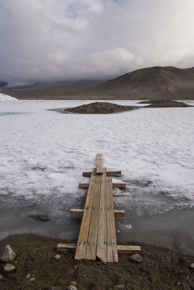
In December, even with temperatures that never get much above freezing, under the 24-hour summer sun a moat melts around the shallow areas of shoreline. The width of the melted water and adjoining thin ice varies and camp manager Rae cautioned that it can change from day to day. So getting out onto the ice on Lake Bonney while I was there only necessitated about a six foot walk on a plank of wood the limnology team placed there, while to get on Hoare a more substantial (although still pretty makeshift) bridge of lumber lashed to pipes was needed, and at Fryxell there was a rowboat with a rope pulley rigged up to cross the much wider moat of shallow water. Once you get onto the lake ice, any ice that’s rough and crunchy is a better bet to walk on than ice that’s smooth and blue, because it’s older and likely to be thicker. Both Bonney and Fryxell were relatively level and stable to walk on once you got across the moat. In fact, on both those lakes, the researchers drive around on an ATV if they have a distance to travel.
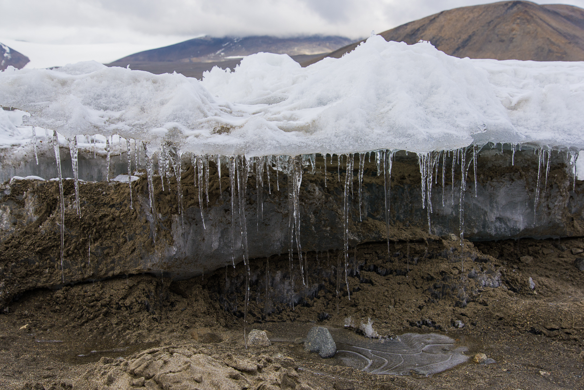
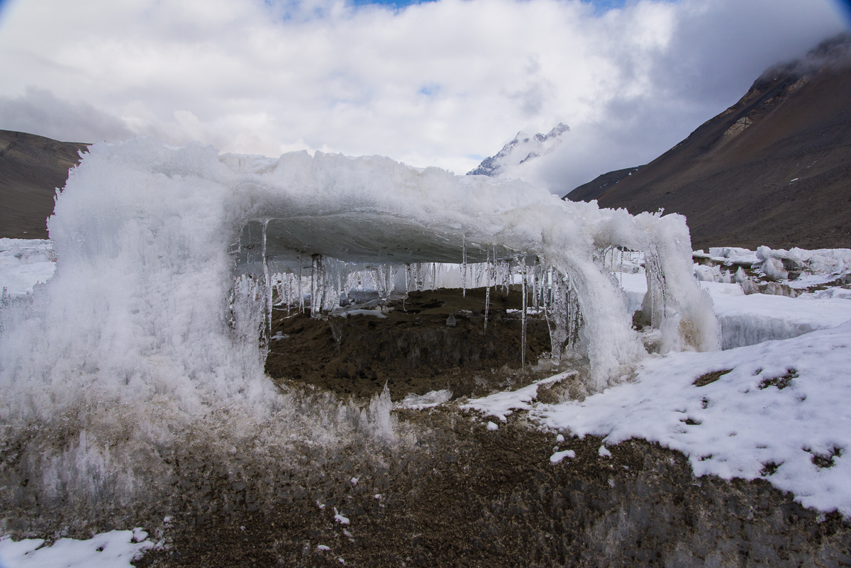
Sometimes it’s difficult to know what’s under the fresh snow surrounding something like this structure (doesn’t it look like a little pavilion?): more sand, firm crunchy ice, or a coating of ice hiding six inches of water.
Hoare is different. Ice that has a thick layer of sediment blown onto it is generally firm to walk on, but you still have to watch where you step or you may end up in ankle-deep — or mid-calf-deep water, as Mari (a McMurdo field center worker who was helping out at the camp the week I was there) and I discovered when we returned from a hike to the other end of Lake Hoare one day. We had hiked down to the Suess Glacier via a little footpath that followed the shoreline, and had been told if we could get onto the ice down there, we could just walk down the middle of the lake on the way back as long as we had on ice crampons, so we wouldn’t slip. We started back on the trail, then after about 10 minutes we saw a spot where we could just take a giant step across the moat onto the lake. This appeared quicker and more direct than the land route we’d taken earlier. Turns out, slipping on slick ice was not the problem. After about 15 or 20 minutes, Mari tripped when her foot abruptly punched through to her mid-calf. She scrambled to her feet. We were both a little spooked, but it seemed to make sense to continue rather than double back. Seemed. Some parts were solid, while others made an ominous hollow sound, and they looked pretty much the same from the top with the slight coating of snow remaining from the storm a few days before, which definitely obscured thin areas that would otherwise have been more obvious. We zigged and zagged from one highly uneven patch of sediment to another, sometimes making good progress, but punching through up to our ankles periodically. This was unexpected after my experiences on Lakes Bonney and Fryxell. I had already walked out onto Hoare with Dave, one of the scientists, and hadn’t encountered this much difficulty. That’s when I took some of these photos — the others I took on another walk onto the lake with him the day after Mari’s and my adventure. But Dave’s been coming here for several years and can size up where to walk pretty readily. At one point, Mari said, “I just remembered, in case you don’t know this, if you fall in, you’re supposed to stick out your arms straight in front of you like this and catch the edge.” Then we started laughing at the absurdity of the situation.
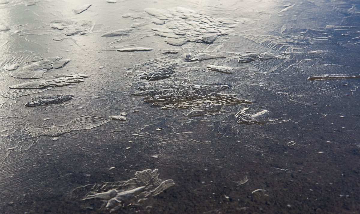
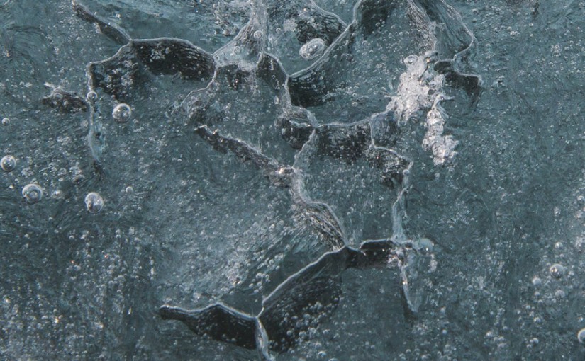
When thin sheets of ice break, they look and sound like broken glass. You can see how some of these ablated areas get hollowed out underneath, and continually melt and refreeze into layers of thin ice.
None of the areas of thin ice were more than a foot deep before you hit the permanent lake ice, but it still was unnerving. Also, sometimes there was no water under the ice, but it shattered with the sound of breaking glass, which I think we’re all hard-wired to find jarring even when we’re not worried about stepping in the wrong place. We didn’t see any narrow moats to cross back to the shore, so we ended up walking cautiously down the middle of the lake, and kept camp manager Rae informed over the two-way radio of our progress. Our “shortcut” ended up taking an extra hour over the path. Boy, were we relieved when we stepped off the bridge onto the shore.
Antarctica continually surprised me. One phenomenon — in this case ablated lake ice — has surprising permutations in one relatively small section of one lake.
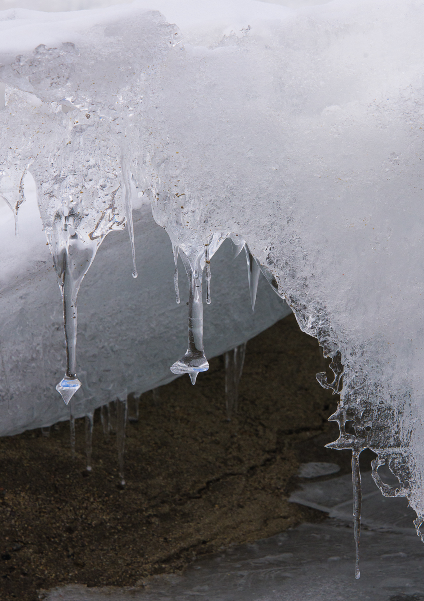
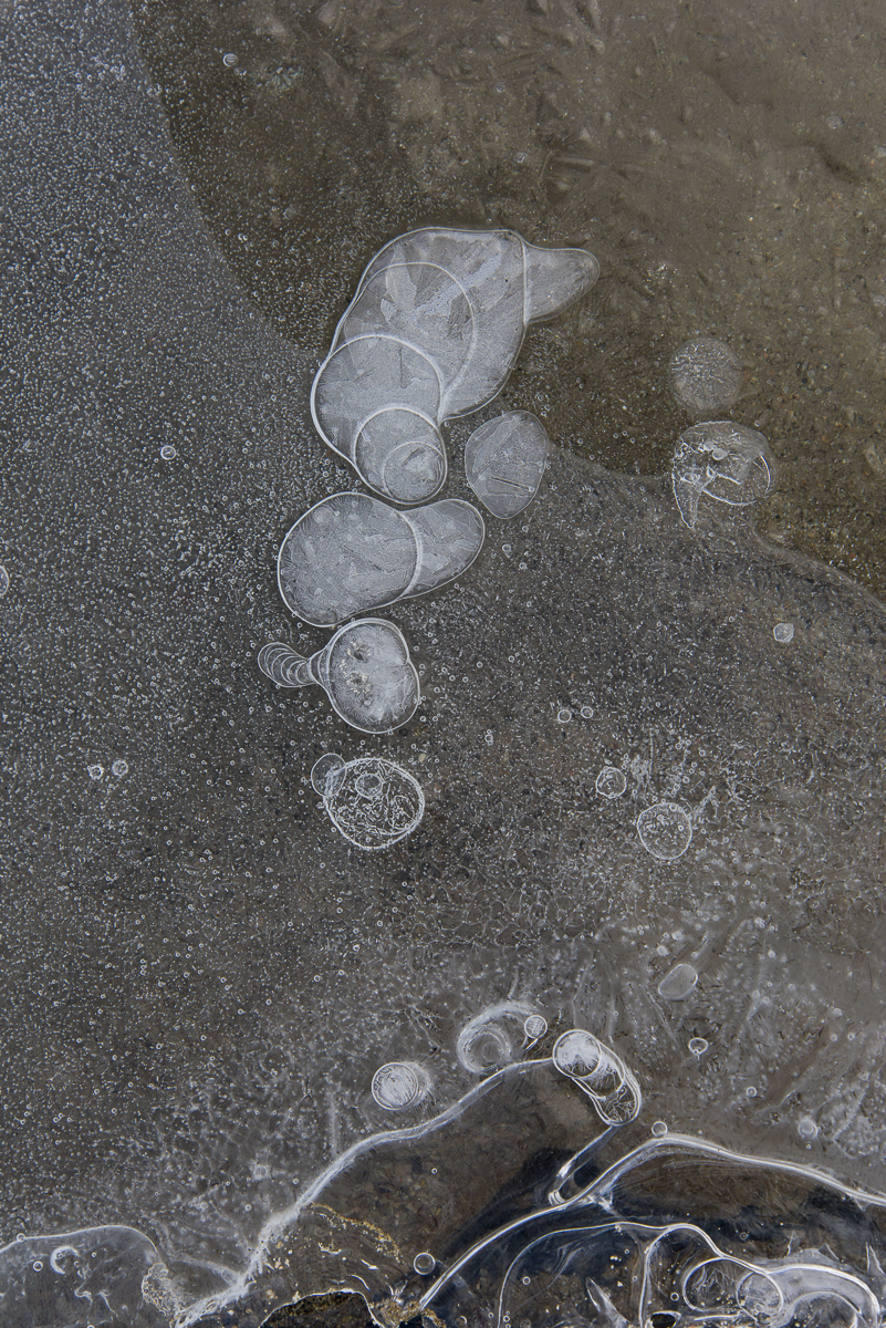
As long as I knew I would not end up in freezing water up to my armpits, I enjoyed walking around with my camera looking for interesting formations and peering inside the taller ones, which were about knee high. There is no shortage of oddities and we didn’t have to walk far to find a wide variety. Some were like thick glass pillars. The ones at left looked like part of a chandelier. Then there was a whole other world of fascinating designs that looked drawn or painted on thin layers of ice that had formed on the surface of the sediment.
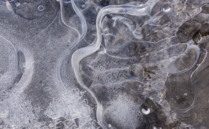
I’ve zoomed in on the formation at left so you can see how a thin ice layer has formed a rainbow-colored interference pattern.
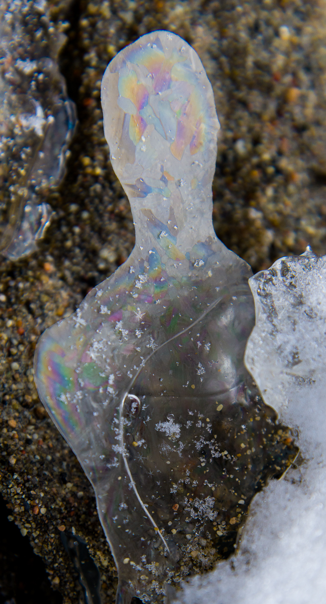
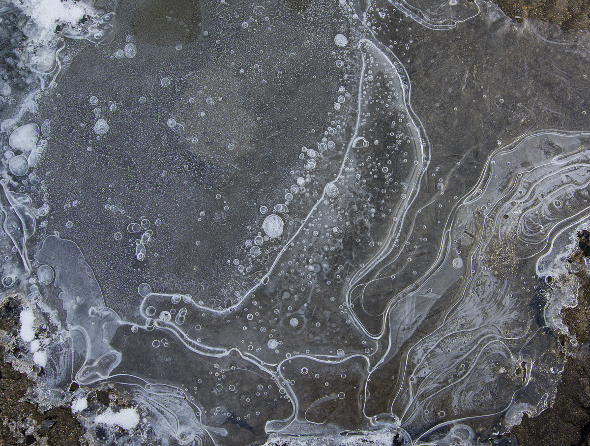
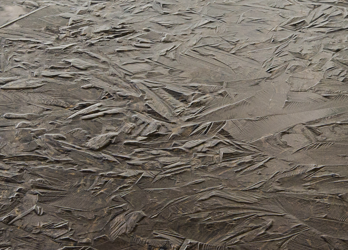
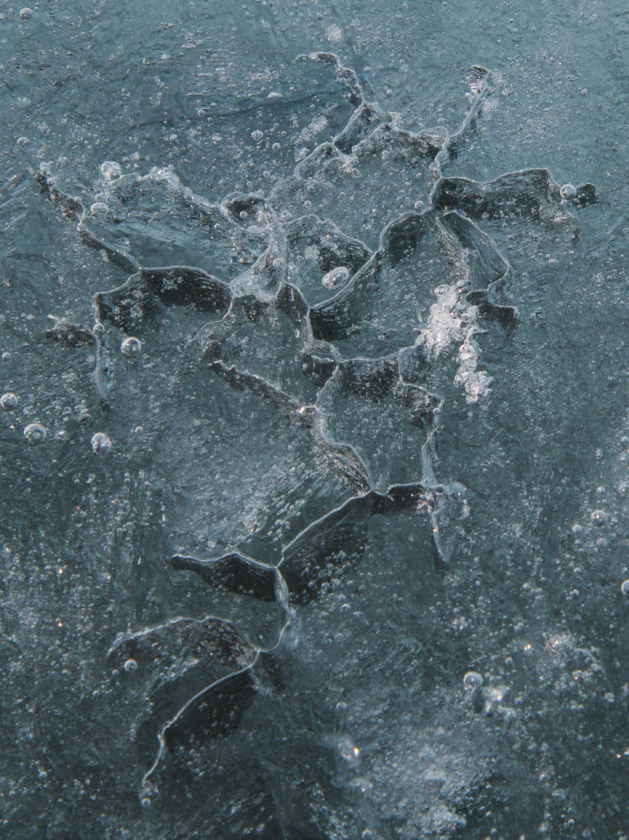
We saw ice embellished with concentric curving lines, overlapping dots, and so-called Tyndall figures, which are pale shapes separated by straight and curved lines. And sometimes there were combinations of any or all of the above as in the following photos:
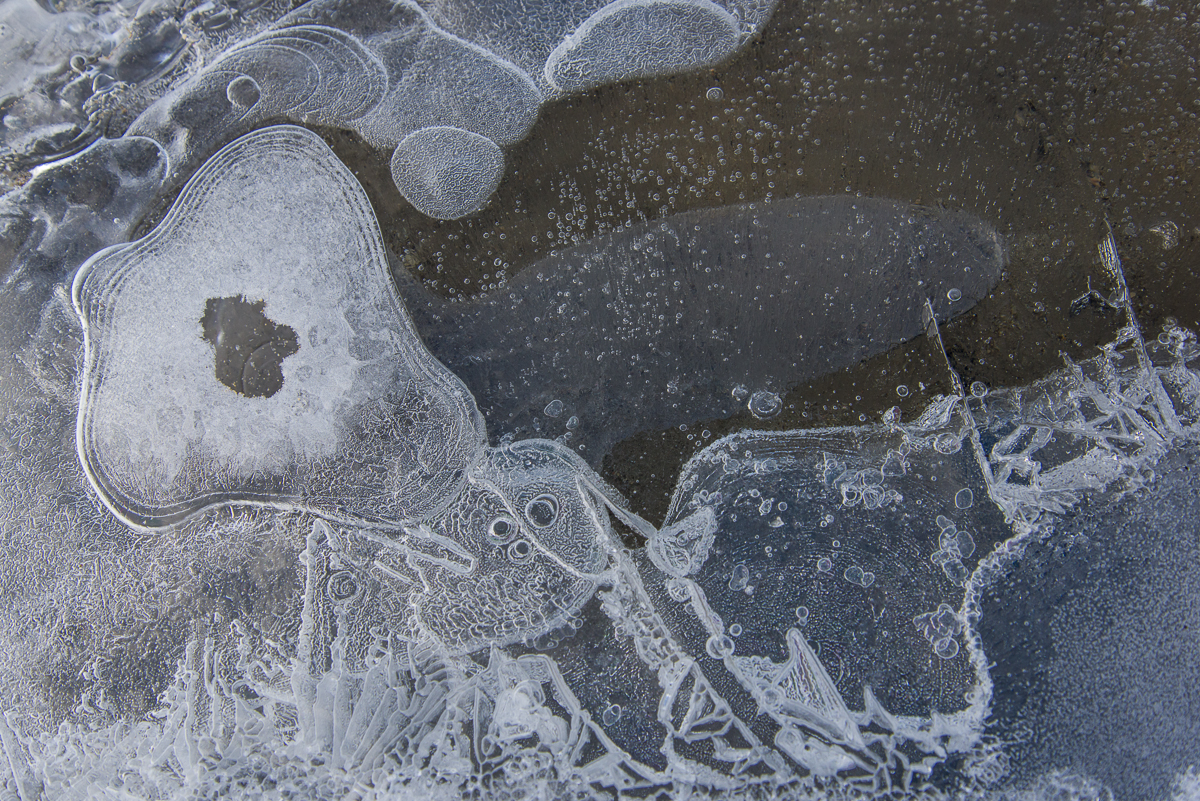
A lake ice trifecta of Tyndall figures, bubbles, and a rainbow-colored interference pattern upper right.I call this one, “The Skua.” Kind of looks like a bird in profile, right? There actually was a skua that sometimes came around the Lake Hoare camp, which the staff and scientists had nicknamed Taylor, since the camp is in the Taylor Valley. Though a lot of people at McMurdo view skuas as pesky, the Hoare camp always got a kick out of seeing Taylor, since he/she was the only bird in the area. Otherwise, the only animals in the Dry Valleys are microbes and nematodes.More abstract art from ice.You can see how thin many of these formations lying on the sediment are.A series of drips freezing a leaving a white outline? A drop leaving traces of its path as it moved? However these formed, the result is delicate and lovely.
Drop dead gorgeous: The Lake Hoare camp is nestled beside the Canada Glacier at one end of the lake. That’s the tent where I slept in the center.
I spent Dec. 18 to Dec. 23 at what may be the most beautiful field camp site in Antarctica. Having seen a grand total of four field camps, I am admittedly not in the best position to judge the fairest of them all, and certainly they all provide fabulous scenery. But when you come out of your tent and towering over you a mere matter of yards away are the glistening white walls of the Canada Glacier with inset vertical crevices of blue ice emitting a turquoise glow, that’s hard to beat. I mean, check out that photo above. That little yellow tent in the middle is where I slept. Now look at the photo below — you crawl out of that tent turn around, and you are that close to it.
White walls with glowing blue crevices — right outside the tent.
The view down the lake from the campsite toward the Suess Glacier (that light-colored triangle you can glimpse at the end of the lake) is not too shabby either:
View up Lake Hoare from the field camp.The main hut at Lake Hoare contains the kitchen, a long table for eating and hanging out, cubbies for keeping items you don’t want to freeze, and plenty of space to work at your laptop or the communal computer. Click this or any of these images to see enlargement.
The Lake Hoare field camp is the first to have the vintage Korean-War-era Jamesway huts replaced. You’ve seen the Jamesways in my posts about New Harbor and Lake Bonney. In the near future, word is that all will be replaced with this more functional rectangular design, that allows for more wall storage, higher ceilings, and windows that you could more easily hang curtains on if you wanted to shut out the 24-hour light. Lake Hoare is a busy camp with three small lab buildings, two “rocket toilets” (outhouses with the capability of incinerating human waste and transforming it to non-polluting ash) plus a standard Antarctic camp outhouse as a backup. The camp is presided over by Rae Spain, a 35-year US Antarctic Program veteran who coordinates the various activities of the Dry Valleys LTER camps, which include Lake Bonney and Lake Fryxell — the comings and goings of the researchers, some of whom move from camp to camp throughout the season, the helicopter supply schedules (due to the number of people working in the area there are frequent visits from helicopters, ferrying passengers, food, water, supplies and waste between McMurdo and the Dry Valleys camps as well as short hops between the camps). Rae is an imposing-looking woman, about six feet tall, who wears her hair in a thick braid that reaches to her hips. She’s organized, efficient, and a masterful cook, one night transforming the field camp ingredients into a tasty dinner of Indian curry. (And in between analyzing soil samples in the lab, Dave, one of the scientists, whipped up some naan dough, which he baked on the outdoor grill to complement the meal. That’s right!) Then there’s Renee, Rae’s assistant and all-around field camp utility player, who, when not occupied with assisting Rae at the hut or the researchers in the field, enjoys baking cookies and other desserts with an attention to detail that would impress Martha Stewart. I digress — but it’s hard not to talk about Lake Hoare without mentioning the food.
Thin ice: during the Antarctic summer sometimes you need to use the bridge to get onto the lake ice.
The research at the Dry Valleys LTER centers on the unusual polar dessert ecosystem, with its mostly ice-free terrain, the stationary Canada Glacier (in other words, it’s grounded and not sliding out to sea) and three perpetually frozen lakes: Lake Bonney, Lake Hoare and Lake Fryxell. (Fryxell is on the other side of the Canada Glacier from Hoare.) The lakes are covered with ice that is about four meters thick, in other words, about 13 feet. That’s just the ice — there’s deep water beneath that. Lake Hoare, for example, has an average depth of 30 feet and a maximum depth of 112 feet. This time of year, the ice at the edges, which is over shallower water, melts in the sun, so there are makeshift bridges to get across to the thicker ice without getting your feet wet, like the one shown at left.
Midnight on a clear night is a great time to photograph this side of the Canada Glacier.
Anyway, late on the evening of the 21st, one by one the camp denizens closed up their laptops, finished their tea or whatever they were doing in the hut and brushed their teeth (field camp life breeds a peculiar intimacy where you floss, brush and spit out your toothpaste into a bucket in front of people you’ve known for all of three days) and went off to their tents to sleep. By about 11:45 p.m. only Dave and I were left, working at our laptops. “The light is really beautiful out there,” Dave remarked. I’d been thinking that I should photograph the glacier in the evening when the light was on it, because in the morning it’s in shadow. The wind was calm, it wasn’t bitter cold, and he was right, the glacier was glowing in the sun against a sapphire sky. So even though I’d hiked to the Suess Glacier and back between 1 and 8:30 p.m. that day, I decided I should take advantage of the conditions and just sleep in the next day. From midnight to almost 2 a.m. I roamed around the campsite taking most of the pictures you see here. The only ones with this post that weren’t taken then are the ones above of the bridge, the hut and the view down the lake toward the Suess Glacier.
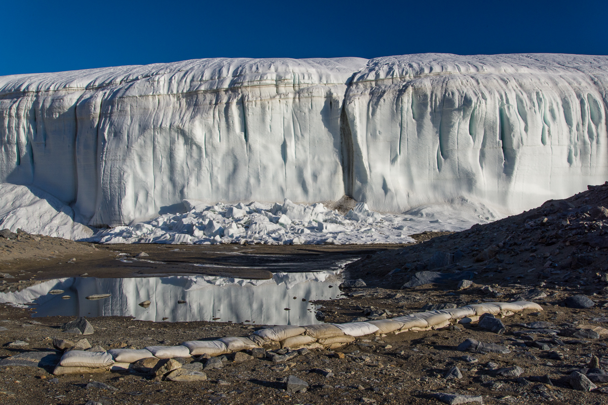
‘Round midnight: Glacier reflected in a pool of water in the vicinity of the stream gauge. In the foreground is a row of sandbags.A metal plaque on the stream gauge box gives pertinent info about the gauge and where to learn more online (click image to read it), as well as noting the box “may be used as emergency shelter by one or two persons.”
This being a LTER (long-term ecological research site) there is a stream gauge to capture the flow of the stream of glacial meltwater that flows down the hill alongside the glacier and into the end of the lake. I came across the above plaque on the side of the gauge box atop one of mounds overlooking the stream, which explains that the stream has a name: Anderson Creek at H1. It also helpfully notes that “This gage [sic] box may be used as an emergency shelter for one or two persons.” That struck me as an odd kind of qualification. What do they mean by one or two? Depending on overall size, shape, interpersonal compatibility and relative degree of distress of said persons? I hadn’t even noticed the gauge before coming across the plaque because it’s tucked behind a mound. It’s not a tall structure so the flow must never get very high:
The stream gauge is in the lower center of the picture.
My initial plan was just to photograph the side of the glacier. But as I was walking around the shoreline, I noticed a lot of beautiful forms in the surface of the lake ice that were thrown into low relief by the light of the midnight sun. Here are a few of my favorites. An NSF glaciologist on station referred me to a lake ice web site where I found some of them:
This is an ice star, also known as an ice spider or ice octopus. According to the lake ice web site, they are holes “associated with water flowing upwards through a hole or crack as the ice sheet is being submerged by the weight of a new snow cover.” We did have a significant snowfall a few days before.
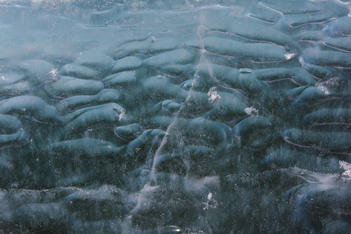
The lake ice web site says this is called “primary ice of the P1 variety” and that it forms in calm conditions moderately below freezing, which is right on target for that day.The lake ice web site goes on to explain, “P1 ice starts as needles growing across a thin, moderately supercooled layer on the surface of the water. They grow until they run into each other. After that, dendritic growth fills in the space between the needles.” In other words, the ice crystals keep branching until they touch other crystals. But it looks like they also grow vertically as well as laterally.More fun with reflections.A detail of the above photo so you can get a sense of the complexity and variety of the ice surface. Reminds me of Asian ceramics.A puddle in the stream bed reflects the bright blue morning sky — 1:30 in the morning that is.
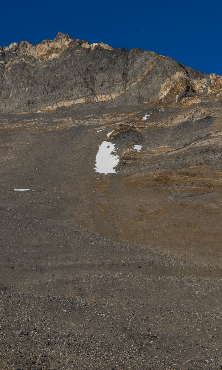
This patch of snow was a Rorschach blot that brought back a repressed memory from my childhood.
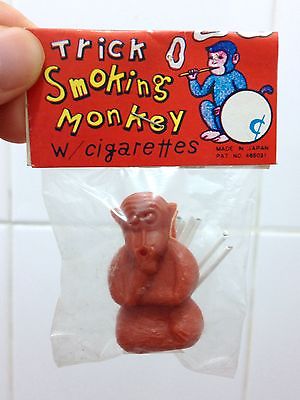
This patch of snow high on a slope above the campsite (left) never changed the entire five days I was there. I privately referred to it as “The Smoking Monkey.” If you’re too young to remember them, Smoking Monkeys were a novelty item for children during the “Mad Men” era, made in Japan — a little plastic monkey with a set of tiny cigarettes the thickness of a toothpick. Put one in its mouth, light it, and the monkey blew tiny smoke rings. For some reason nobody thought this was an inappropriate toy. You think I’m just blowing smoke? Here’s one that’s for sale on eBay:
Enough about smoking monkeys. I’ll bring this post to a close by waving goodbye:
Glacier with the shadows the stream gauge box and me.
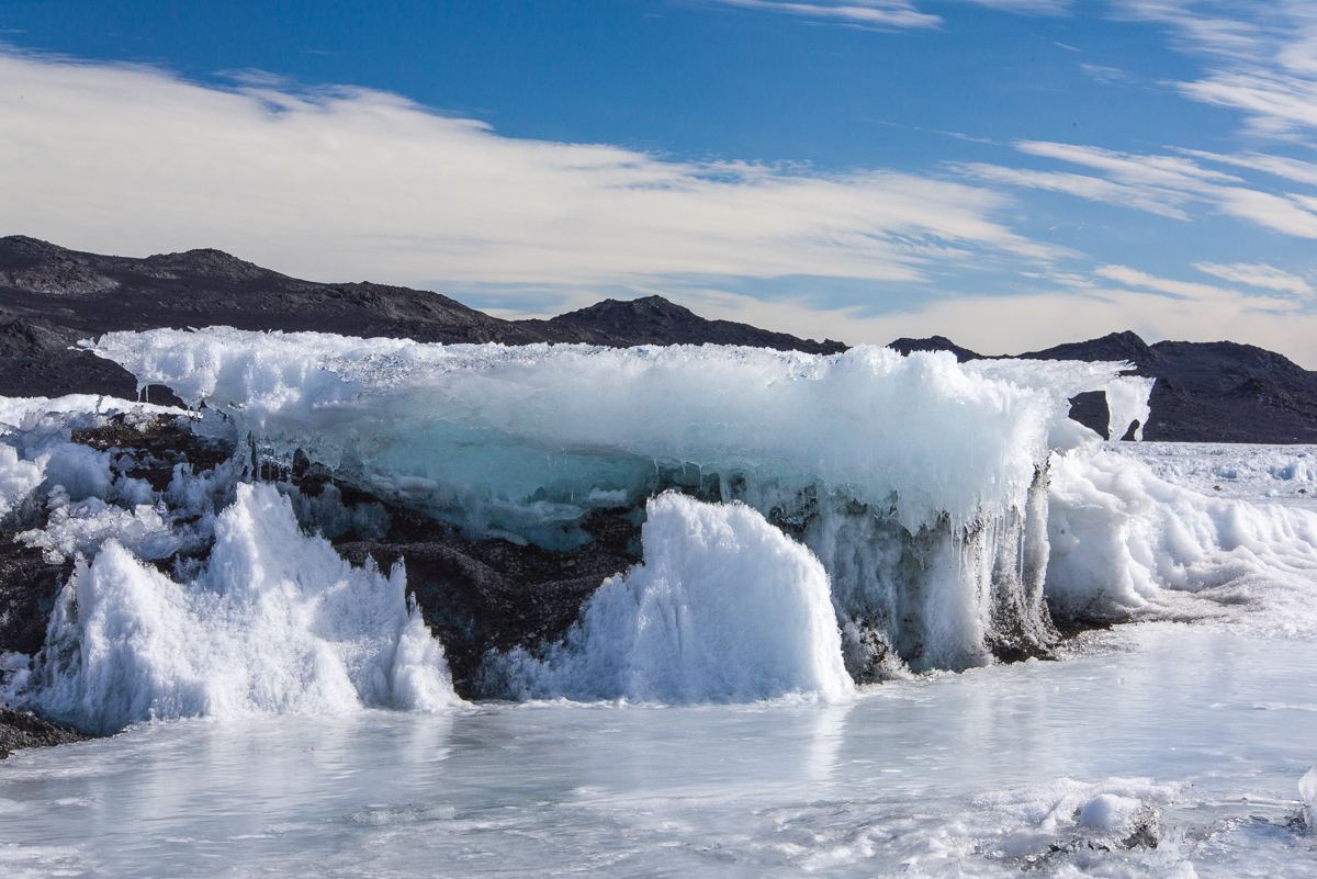
This bumpy ice at the edge of one of the inland lakes at Cape Royds looked like flash-frozen oblong bubbles.
For my Antarctic Artists and Writers Program project, I expected to be photographing glaciers and large ice formations, but once I got to Cape Royds and the Dry Valleys, I also discovered some small scale — even tiny — ones that fascinated me in their variety and the unexpected shapes or colors. It seems that the extreme cold of Antarctica generates some peculiar ice formations in the freshwater lakes fed by glaciers.
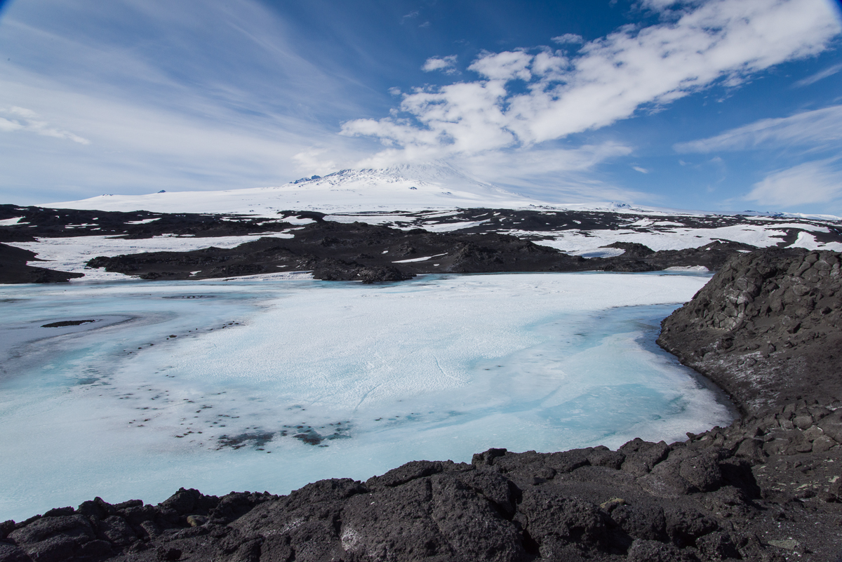
Looks like waves lapping on the lake shore, but they’re completely frozen.One of the large lakes at Cape Royds. Mt. Erebus is in the distance. The first couple of days I was there, the lake was frozen and you could walk right onto it from the shore and cross to the middle. That’s when I took these photos. But a couple of days later, the edges had thawed and there was no way to get to the ice without wading across a few feet of water.
Some of these lakes melt around the edges this time of year (December-January), but never thaw completely. I don’t know if the kind of ice formations you’ll see in the photos that follow are found elsewhere in other places that are cold much of the year, for example, the Arctic. Nobody I’ve asked so far could tell me, but then again, most people who are working in those places as mountaineer guides or researchers aren’t attending to that ice, except as a practical matter to check out if it’s safe to walk on it. So if anyone reading this has more information about what physical processes are causing these shapes, feel free to comment!
A close-up of a jagged ice pattern found walking along the black sand beach at Cape Royds. It’s pretty much all straight lines.
It also could be at Cape Royds that because of its proximity to the sea, there are salts in the water that are contributing to some of these effects. This cracking pattern at the left was not photographed at the lake, but at the edge of a black sand beach where there was a pressure ridge and sea ice. But snow was melting from a ridge above the beach so it’s hard to say if it’s frozen freshwater or frozen sea water or a combination.
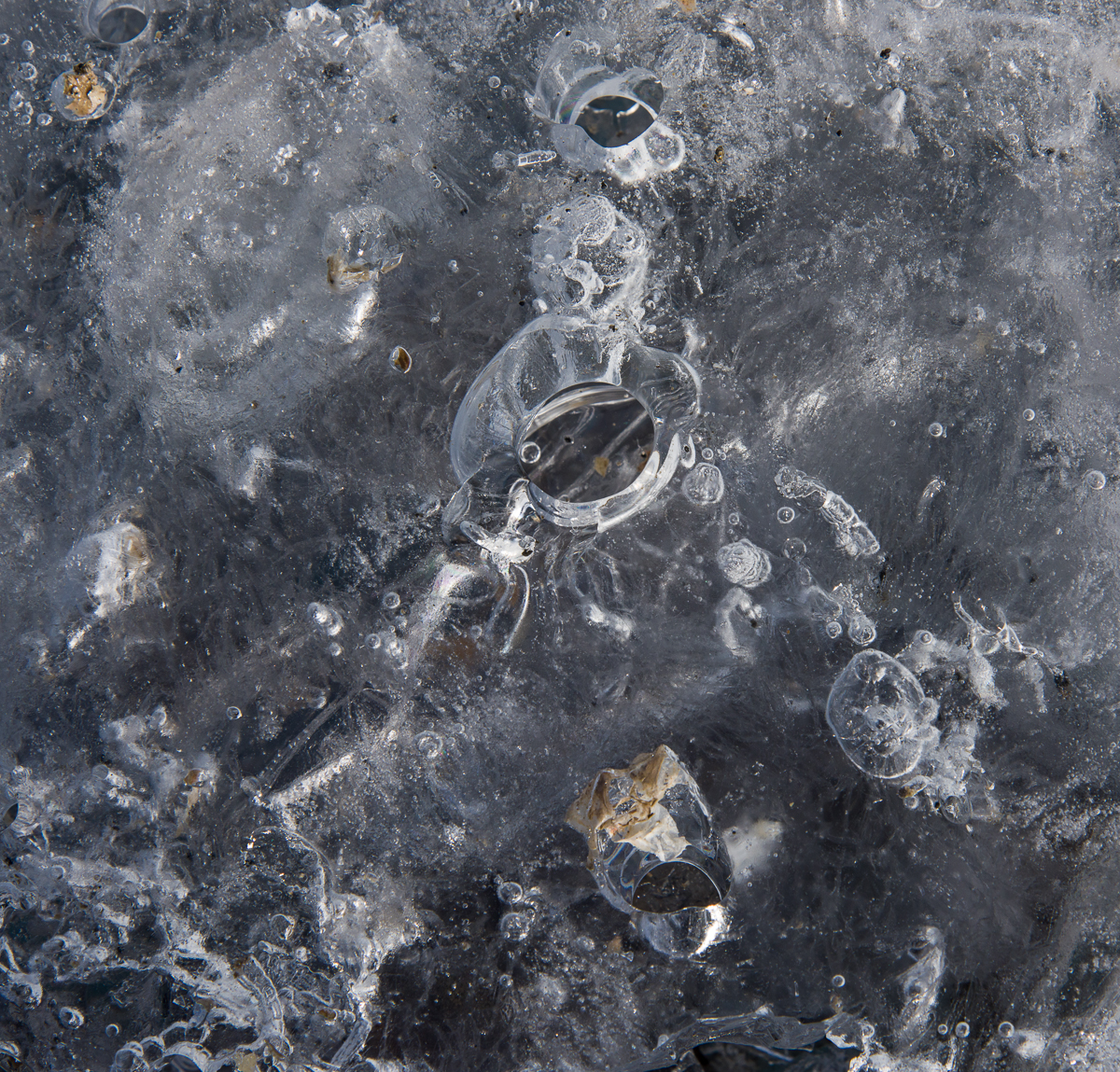
Ice structure in the middle of a lake at Cape Royds. The ice around it was thick and solid enough to walk on.
Some of the unusual patterns I found were at the center of one of the inland lakes at Royds, where gravel from the surrounding hills had blown onto the ice, piled up there, and there was a frozen flat-topped ice structure sitting on top of it. There were a lot of these isolated flat-topped ice structures at Lake Hoare in the Dry Valleys, too. The ice designs I found at Lake Hoare will be the subject of a later blog post. The explanation I got at Hoare was that while the ice forms from the bottom (and in the Dry Valleys the lake ice is a few meters thick), the frozen surface of the lake ice ablates — that is, vaporizes into the air — but sometimes leaves areas that haven’t ablated still sticking up above the frozen lake surface. The next few photos were taken near one of those structures, shown in the above photo. It was probably about three feet high, several feet wide and extended for several feet in the middle of the lake. You can see in the photo there was a lot of sediment around it.
This design, photographed near the formation shown above, has rounded shapes, within which are a combination of straight lines and curves. And it has distinct layers at different depths, presumably from freezing and melting and refreezing at different times.
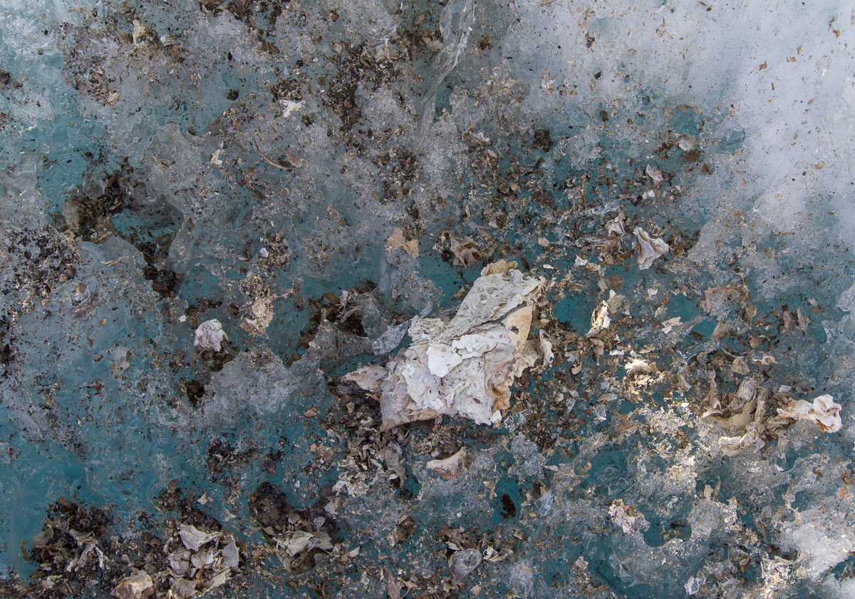
In the lakes at Cape Royds you’ll also find what looks like torn up bits of cream, tan and orange paper scattered on top of and within the ice. Those are algal mats. Around that tabletop shaped formation at the center of the lake were these “collages”:
An algal mat “collage” in the lake ice.This one looks like someone splattered turquoise paint on it. You can see where gravel has blown onto the ice and piled up. The gravel melts holes in the ice, too.This microworld of a thick layer of ice on top of sediment has some scattered fragments of algal mat, frozen bubbles of varying size and holes. It was taken nearby the two photos above.
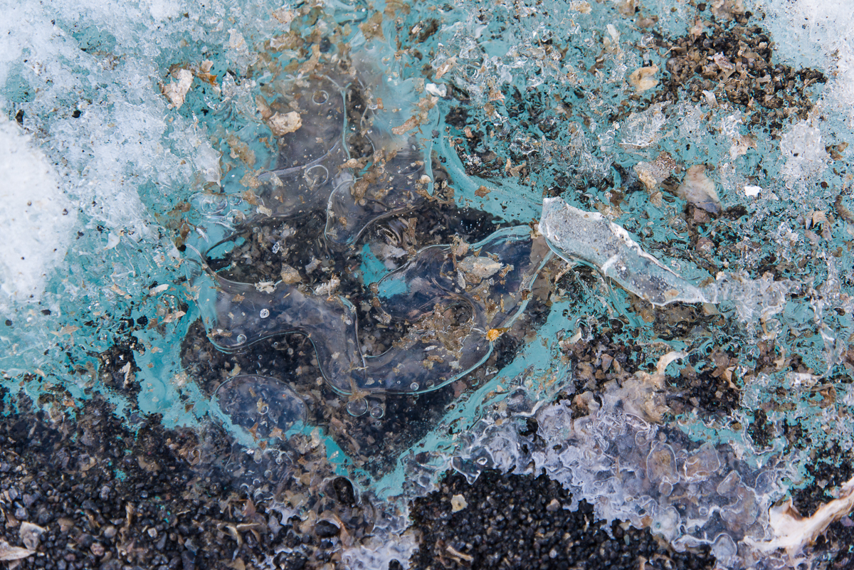
I’ve saved the strangest formation for last. This one was by the shore. The ice was a deep shade of turquoise, and inside were vertical ribbons caused by…what? They were definitely three-dimensional as you moved around them. I’m trying to find out what causes them. They looked to be about 3/4 of an inch wide. Here’s an overall photo and a detail:
Ribbons in the ice: anyone know what causes these? I also saw similar patterns in Lake Hoare but the ribbons were not nearly as wide, nor were they colorful, just plain white.Detail of the ice ribbons.
In a future post I’ll show some of the small surface ice formations from Lake Hoare, which were different than these. I’ve encountered much more variety of ice in Antarctica than I had expected, a happy discovery.